geobeam adds GIS capabilities to your Apache Beam pipelines.
geobeam enables you to ingest and analyze massive amounts of geospatial data in parallel using Dataflow.
geobeam provides a set of FileBasedSource
classes that make it easy to read, process, and write geospatial data, and provides a set of helpful
Apache Beam transforms and utilities that make it easier to process GIS data in your Dataflow pipelines.
See the Full Documentation for complete API specification.
- Apache Beam 2.46+
- Python 3.8+
Note: Make sure the Python version used to run the pipeline matches the version in the built container.
| File format | Data type | Geobeam class |
|---|---|---|
tiff |
raster | RasterBlockSource and RasterPolygonSource |
shp |
vector | ShapefileSource |
gdb |
vector | GeodatabaseSource |
json |
vector | GeoJSONSource |
| URL | vector | ESRIServerSource |
geobeam includes several python modules that allow you to perform a wide variety of operations and analyses on your geospatial data.
| Module | Version | Description |
|---|---|---|
| gdal | 3.5.2 | python bindings for GDAL |
| rasterio | 1.3.2 | reads and writes geospatial raster data |
| fiona | 1.8.21 | reads and writes geospatial vector data |
| shapely | 1.8.4 | manipulation and analysis of geometric objects in the cartesian plane |
| esridump | 1.11.0 | read layer from ESRI server |
pip install geobeam
Write a normal Apache Beam pipeline using one of geobeams file sources.
See geobeam/examples for inspiration.
python -m geobeam.examples.geotiff_dem \
  --gcs_url gs://geobeam/examples/dem-clipped-test.tif \
  --dataset examples \
  --table dem \
  --band_column elev \
  --runner DirectRunner \
  --temp_location <temp gs://> \
  --project <project_id>
Note: Some of the provided examples may take a very long time to run locally...
This will run in Dataflow as a custom container based on the dataflow-geobeam/base image.
It is recommended that you publish your own container based on the Dockerfile in this repository and store it in your project's GCR registry.
FROM gcr.io/dataflow-geobeam/base

RUN pip install geobeam

COPY requirements.txt .
RUN pip install -r requirements.txt

COPY . .
# build locally with docker
docker build -t gcr.io/<project_id>/geobeam
docker push gcr.io/<project_id>/geobeam
# or build with Cloud Build
gcloud builds submit --timeout 3600s --worker_machine_type n1-highcpu-8# run the geotiff_soilgrid example in dataflow
python -m geobeam.examples.geotiff_soilgrid \
--gcs_url gs://geobeam/examples/AWCh3_M_sl1_250m_ll.tif \
--dataset examples \
--table soilgrid \
--band_column h3 \
--runner DataflowRunner \
--sdk_container_image gcr.io/dataflow-geobeam/base \
--temp_location <temp bucket> \
--service_account_email <service account> \
--region us-central1 \
--max_num_workers 2 \
--worker_machine_type c2-standard-30 \
def run(options):
  from geobeam.io import RasterBlockSource
  from geobeam.fn import format_rasterblock_record

  with beam.Pipeline(options) as p:
    (p  | 'ReadRaster' >> beam.io.Read(RasterBlockSource(gcs_url))
        | 'FormatRecord' >> beam.Map(format_rasterblock_record)
| 'WriteToBigquery' >> beam.io.WriteToBigQuery('geo.dem'))def run(options):
from geobeam.io import ShapefileSource
from geobeam.fn import make_valid, filter_invalid, format_record
with beam.Pipeline(options) as p:
(p | 'ReadShapefile' >> beam.io.Read(ShapefileSource(gcs_url))
| 'Validate' >> beam.Map(make_valid)
| 'FilterInvalid' >> beam.Filter(filter_invalid)
| 'FormatRecord' >> beam.Map(format_record)
| 'WriteToBigquery' >> beam.io.WriteToBigQuery('geo.parcel'))See geobeam/examples/ for complete examples.
A number of example pipelines are available in the geobeam/examples/ folder.
To run them in your Google Cloud project, run the included terraform file to set up the Bigquery dataset and tables used by the example pipelines.
Open up Bigquery GeoViz to visualize your data.
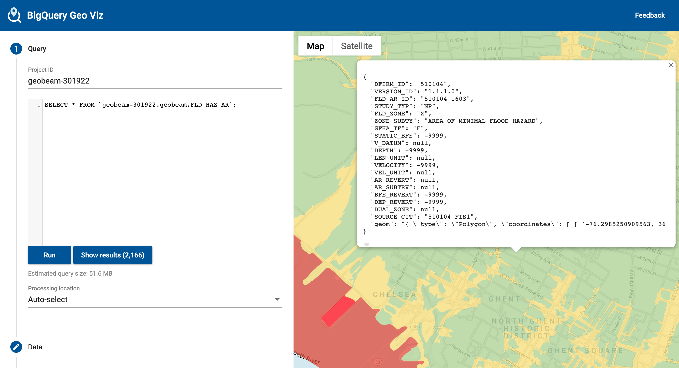
The National Flood Hazard Layer loaded from a shapefile. Example pipeline at geobeam/examples/shapefile_nfhl.py
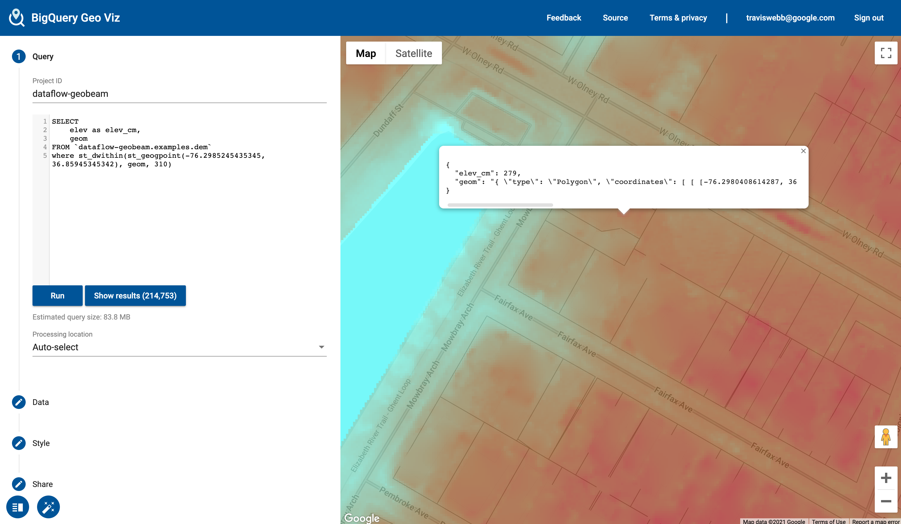
The Digital Elevation Model is a high-resolution model of elevation measurements at 1-meter resolution. (Values converted to centimeters). Example pipeline: geobeam/examples/geotiff_dem.py.
The geobeam.fn module includes several Beam Transforms that you can use in your pipelines.
| Module | Description |
|---|---|
geobeam.fn.make_valid |
Attempt to make all geometries valid. |
geobeam.fn.filter_invalid |
Filter out invalid geometries that cannot be made valid |
geobeam.fn.format_record |
Format the (props, geom) tuple received from a vector source into a dict that can be inserted into the destination table |
geobeam.fn.format_rasterblock_record |
Format the output record for blocks read from RasterBlockSource |
geobeam.fn.format_rasterpolygon_record |
Format the output record for blocks read from RasterPolygonSource |
Each FileSource accepts several parameters that you can use to configure how your data is loaded and processed. These can be parsed as pipeline arguments and passed into the respective FileSources as seen in the examples pipelines.
| Parameter | Input type | Description | Default | Required? |
|---|---|---|---|---|
skip_reproject |
All | True to skip reprojection during read | False |
No |
in_epsg |
All | An EPSG integer to override the input source CRS to reproject from | No | |
in_proj |
All | A PROJ string to override the input source CRS | No | |
band_number |
Raster | The raster band to read from | 1 |
No |
include_nodata |
Raster | True to include nodata values |
False |
No |
return_block_transform |
Raster | True to include rasterio transform object with each block to use with geobeam.fn.format_rasterpixel_record |
False |
No |
layer_name |
Vector | Name of layer to read | Yes, for shapefiles | |
gdb_name |
Vector | Name of geodatabase directory in a gdb zip archive | Yes, for GDB files |
This is not an officially supported Google product, though support will be provided on a best-effort basis.
Copyright 2023 Google LLC

Licensed under the Apache License, Version 2.0 (the "License");
you may not use this file except in compliance with the License.
You may obtain a copy of the License at

    https://www.apache.org/licenses/LICENSE-2.0

Unless required by applicable law or agreed to in writing, software
distributed under the License is distributed on an "AS IS" BASIS,
WITHOUT WARRANTIES OR CONDITIONS OF ANY KIND, either express or implied.
See the License for the specific language governing permissions and
limitations under the License.