Program that shows all the details of the given IP address. Build with Python and ipinfo.io API

Overview

ip-details

This is a program that shows all the details of the given IP address. Build with Python and ipinfo.io API

Usage

To use this program, run the main Batch or Shell file, entering an IPv4 address as argument.

$ ip 1.1.1.1

You can also add the --save or -s flag, to save the output to a file. The file will be named details.log, and will be stored inside the saves directory of the program (saves/details.log).

$ ip 1.1.1.1 --save

Or, if prefered:

$ ip 1.1.1.1 -s

Example

$ ip 1.1.1.1

IP : 1.1.1.1
CITY : Miami
REGION : Florida
COUNTRY : US
LOC : 25.7867,-80.1800
ORG : AS13335 Cloudflare, Inc.
POSTAL : 33132
TIMEZONE : America/New_York
MAP : https://maps.google.com/maps/search/25.7867,-80.1800

And with the save option:

$ ip 1.1.1.1 --save

IP : 1.1.1.1
CITY : Miami
REGION : Florida
COUNTRY : US
LOC : 25.7867,-80.1800
ORG : AS13335 Cloudflare, Inc.
POSTAL : 33132
TIMEZONE : America/New_York
MAP : https://maps.google.com/maps/search/25.7867,-80.1800

Data saved to saves/details.log

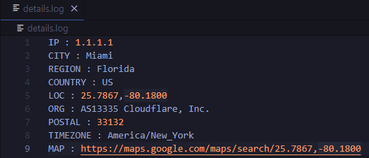
details.log file:

image

Requirements

Python programming language

Requests python library (pip install requests)
A public data repository for datasets created from TransLink GTFS data.

TransLink Spatial Data What: TransLink is the statutory public transit authority for the Metro Vancouver region. This GitHub repository is a collectio

Henry Tang 3 Jan 14, 2022
Expose a GDAL file as a HTTP accessible on-the-fly COG

cogserver Expose any GDAL recognized raster file as a HTTP accessible on-the-fly COG (Cloud Optimized GeoTIFF) The on-the-fly COG file is not material

Even Rouault 73 Aug 04, 2022
Simulation and Parameter Estimation in Geophysics

Simulation and Parameter Estimation in Geophysics - A python package for simulation and gradient based parameter estimation in the context of geophysical applications.

SimPEG 390 Dec 15, 2022
Spatial Interpolation Toolbox is a Python-based GUI that is able to interpolate spatial data in vector format.

Spatial Interpolation Toolbox This is the home to Spatial Interpolation Toolbox, a graphical user interface (GUI) for interpolating geographic vector

Michael Ward 2 Nov 01, 2021
:earth_asia: Python Geocoder

Python Geocoder Simple and consistent geocoding library written in Python. Table of content Overview A glimpse at the API Forward Multiple results Rev

Denis 1.5k Jan 02, 2023
Read and write rasters in parallel using Rasterio and Dask

dask-rasterio dask-rasterio provides some methods for reading and writing rasters in parallel using Rasterio and Dask arrays. Usage Read a multiband r

Dymaxion Labs 85 Aug 30, 2022
python toolbox for visualizing geographical data and making maps

geoplotlib is a python toolbox for visualizing geographical data and making maps data = read_csv('data/bus.csv') geoplotlib.dot(data) geoplotlib.show(

Andrea Cuttone 976 Dec 11, 2022
Python script that can be used to generate latitude/longitude coordinates for GOES-16 full-disk extent.

goes-latlon Python script that can be used to generate latitude/longitude coordinates for GOES-16 full-disk extent. 🌎 🛰️ The grid files can be acces

Douglas Uba 3 Apr 06, 2022
Read images to numpy arrays

mahotas-imread: Read Image Files IO with images and numpy arrays. Mahotas-imread is a simple module with a small number of functions: imread Reads an

Luis Pedro Coelho 67 Jan 07, 2023
Simple CLI for Google Earth Engine Uploads

geeup: Simple CLI for Earth Engine Uploads with Selenium Support This tool came of the simple need to handle batch uploads of both image assets to col

Samapriya Roy 79 Nov 26, 2022
OSMnx: Python for street networks. Retrieve, model, analyze, and visualize street networks and other spatial data from OpenStreetMap.

OSMnx OSMnx is a Python package that lets you download geospatial data from OpenStreetMap and model, project, visualize, and analyze real-world street

Geoff Boeing 4k Jan 08, 2023
A service to auto provision devices in Aruba Central based on the Geo-IP location

Location Based Provisioning Service for Aruba Central A service to auto provision devices in Aruba Central based on the Geo-IP location Geo-IP auto pr

Will Smith 3 Mar 22, 2022
Using Global fishing watch's data to build a machine learning model that can identify illegal fishing and poaching activities through satellite and geo-location data.

Using Global fishing watch's data to build a machine learning model that can identify illegal fishing and poaching activities through satellite and geo-location data.

Ayush Mishra 3 May 06, 2022
Python library to visualize circular plasmid maps

Plasmidviewer Plasmidviewer is a Python library to visualize plasmid maps from GenBank. This library provides only the function to visualize circular

Mori Hideto 9 Dec 04, 2022
iNaturalist observations along hiking trails

This tool reads the route of a hike and generates a table of iNaturalist observations along the trails. It also shows the observations and the route of the hike on a map. Moreover, it saves waypoints

7 Nov 11, 2022
Google maps for Jupyter notebooks

gmaps gmaps is a plugin for including interactive Google maps in the IPython Notebook. Let's plot a heatmap of taxi pickups in San Francisco: import g

Pascal Bugnion 747 Dec 19, 2022
Raster-based Spatial Analysis for Python

🌍 xarray-spatial: Raster-Based Spatial Analysis in Python 📍 Fast, Accurate Python library for Raster Operations ⚡ Extensible with Numba ⏩ Scalable w

makepath 649 Jan 01, 2023
Tool to suck data from ArcGIS Server and spit it into PostgreSQL

chupaESRI About ChupaESRI is a Python module/command line tool to extract features from ArcGIS Server map services. Name? Think "chupacabra" or "Chupa

John Reiser 34 Dec 04, 2022
Geodata extensions for Django REST Framework

Django-Spillway Django and Django REST Framework integration of raster and feature based geodata. Spillway builds on the immensely marvelous Django RE

Brian Galey 62 Jan 04, 2023
PyTorch implementation of ''Background Activation Suppression for Weakly Supervised Object Localization''.

Background Activation Suppression for Weakly Supervised Object Localization PyTorch implementation of ''Background Activation Suppression for Weakly S

34 Dec 27, 2022