Using Global fishing watch's data to build a machine learning model that can identify illegal fishing and poaching activities through satellite and geo-location data.

Overview

Catching-Illegal-Fishing

Using Global fishing watch's data to build a machine learning model that can identify illegal fishing and poaching activities through satellite and geo-location data.

Global fishing watch is a partnership between Google and Oceana to map all trackable fishing activity in world, in almost real time. This is a personal project using the data provided by global fishing watch.

The data provided has vessel ids, types and coordinates of encountered vessels.

Given same vessel type and are, a fishing vessel has a different trajectory than a non fishing vessel. I used the data provided to train my model on predicting whether a vessel is fishing or not.

#Local Environment Setup Python 3.7++ Tensorflow version >1.14.0,<2.0 from (https://www.tensorflow.org/get_started/os_setup) pip install google-api-python-client pyyaml pytz newlinejson python-dateutil yattag

#Model Result image

image

image

image

image

image

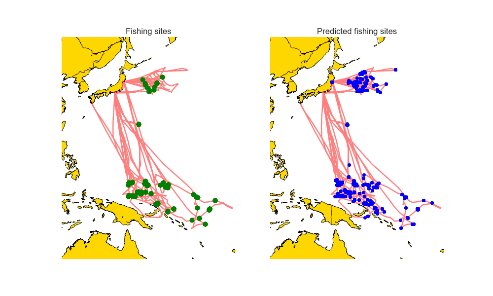
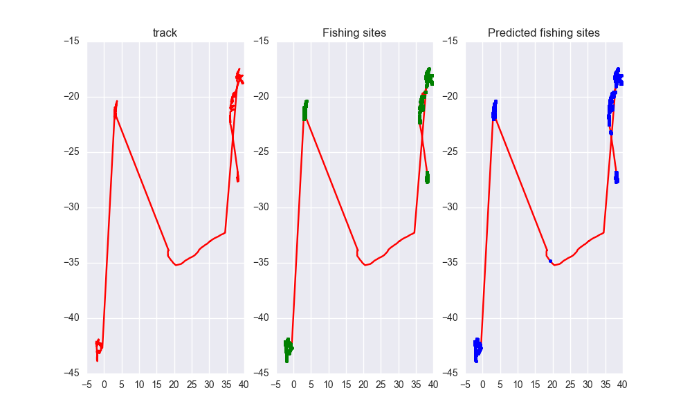
As you can see the predicted tracks are extremely close to the real paths.
Owner
Ayush Mishra
Machine Learning enthusiast.
Ayush Mishra
Rasterio reads and writes geospatial raster datasets

Rasterio Rasterio reads and writes geospatial raster data. Geographic information systems use GeoTIFF and other formats to organize and store gridded,

Mapbox 1.9k Jan 07, 2023
Get Landsat surface reflectance time-series from google earth engine

geextract Google Earth Engine data extraction tool. Quickly obtain Landsat multispectral time-series for exploratory analysis and algorithm testing On

Loïc Dutrieux 50 Dec 15, 2022
Tools for the extraction of OpenStreetMap street network data

OSMnet Tools for the extraction of OpenStreetMap (OSM) street network data. Intended to be used in tandem with Pandana and UrbanAccess libraries to ex

Urban Data Science Toolkit 47 Sep 21, 2022
Introduction to Geospatial Analysis in Python

Introduction to Geospatial Analysis in Python This repository is in support of a talk on geospatial data. Data To recreate all of the examples, the da

Dillon Gardner 6 Oct 19, 2022
Python module and script to interact with the Tractive GPS tracker.

pyTractive GPS Python module and script to interact with the Tractive GPS tracker. Requirements Python 3 geopy folium pandas pillow usage: main.py [-h

Dr. Usman Kayani 3 Nov 16, 2022
EOReader is a multi-satellite reader allowing you to open optical and SAR data.

Remote-sensing opensource python library reading optical and SAR sensors, loading and stacking bands, clouds, DEM and index.

ICube-SERTIT 152 Dec 30, 2022
Fiona reads and writes geographic data files

Fiona Fiona reads and writes geographic data files and thereby helps Python programmers integrate geographic information systems with other computer s

987 Jan 04, 2023
LEOGPS - Satellite Navigation with GPS on Python!

LEOGPS is an open-source Python software which performs relative satellite navigation between two formation flying satellites, with the objective of high accuracy relative positioning. Specifically,

Samuel Low 50 Dec 13, 2022
Ingest and query genomic intervals from multiple BED files

Ingest and query genomic intervals from multiple BED files.

4 May 29, 2021
OSMnx: Python for street networks. Retrieve, model, analyze, and visualize street networks and other spatial data from OpenStreetMap.

OSMnx OSMnx is a Python package that lets you download geospatial data from OpenStreetMap and model, project, visualize, and analyze real-world street

Geoff Boeing 4k Jan 08, 2023
Daily social mapping project in November 2021. Maps made using PyGMT whenever possible.

Daily social mapping project in November 2021. Maps made using PyGMT whenever possible.

Wei Ji 20 Nov 24, 2022
WIP: extracting Geometry utilities from datacube-core

odc.geo This is still work in progress. This repository contains geometry related code extracted from Open Datacube. For details and motivation see OD

Open Data Cube 34 Jan 09, 2023
h3-js provides a JavaScript version of H3, a hexagon-based geospatial indexing system.

h3-js The h3-js library provides a pure-JavaScript version of the H3 Core Library, a hexagon-based geographic grid system. It can be used either in No

Uber Open Source 648 Jan 07, 2023
gpdvega is a bridge between GeoPandas and Altair that allows to seamlessly chart geospatial data

gpdvega gpdvega is a bridge between GeoPandas a geospatial extension of Pandas and the declarative statistical visualization library Altair, which all

Ilia Timofeev 49 Jul 25, 2022
This app displays interesting statistical weather records and trends which can be used in climate related research including study of global warming.

This app displays interesting statistical weather records and trends which can be used in climate related research including study of global warming.

0 Dec 27, 2021
leafmap - A Python package for geospatial analysis and interactive mapping in a Jupyter environment.

A Python package for geospatial analysis and interactive mapping with minimal coding in a Jupyter environment

Qiusheng Wu 1.4k Jan 02, 2023
Program that shows all the details of the given IP address. Build with Python and ipinfo.io API

ip-details This is a program that shows all the details of the given IP address. Build with Python and ipinfo.io API Usage To use this program, run th

4 Mar 01, 2022
Calculate the area inside of any GeoJSON geometry. This is a port of Mapbox's geojson-area for Python

geojson-area Calculate the area inside of any GeoJSON geometry. This is a port of Mapbox's geojson-area for Python. Installation $ pip install area U

Alireza 87 Dec 14, 2022
Constraint-based geometry sketcher for blender

Geometry Sketcher Constraint-based sketcher addon for Blender that allows to create precise 2d shapes by defining a set of geometric constraints like

1.7k Jan 02, 2023
A NASA MEaSUREs project to provide automated, low latency, global glacier flow and elevation change datasets

Notebooks A NASA MEaSUREs project to provide automated, low latency, global glacier flow and elevation change datasets This repository provides tools

NASA Jet Propulsion Laboratory 27 Oct 25, 2022