Mmdb-server - An open source fast API server to lookup IP addresses for their geographic location

Overview

mmdb-server

mmdb-server is an open source fast API server to lookup IP addresses for their geographic location. The server can be used with any MaxMind DB File Format or file in the same format.

mmdb-server includes a free and open GeoOpen-Country database for IPv4 and IPv6 addresses. The file GeoOpen-Country is generated on a regular basis from AS announces and their respective whois records.

Installation

Python 3.8+ is required to run the mmdb-server with some additional requirements.

  • pip3 install -r REQUIREMENTS
  • cp ./etc/server.conf.sample ./etc/server.conf
  • cd bin; python3 server.py

Usage

Lookup of an IP address

curl -s http://127.0.0.1:8000/geolookup/188.65.220.25 | jq .

[
  {
    "country": {
      "iso_code": "BE"
    },
    "meta": {
      "description": {
        "en": "Geo Open MMDB database - https://github.com/adulau/mmdb-server"
      },
      "build_db": "2022-01-23 16:13:05",
      "db_source": "GeoOpen-Country",
      "nb_nodes": 1156125
    }
  }
]

$ curl -s http://127.0.0.1:8000/geolookup/2a02:21d0::68:69:25 | jq .

[
  {
    "country": {
      "iso_code": "BE"
    },
    "meta": {
      "description": {
        "en": "Geo Open MMDB database - https://github.com/adulau/mmdb-server"
      },
      "build_db": "2022-01-23 16:13:05",
      "db_source": "GeoOpen-Country",
      "nb_nodes": 1156125
    }
  }
]

Output format

The output format is an array of JSON object (to support the ability to serve multiple geo location database). Each JSON object of the JSON array includes a meta and a country fields. The country give the geographic location of the IP address queried. The meta field includes the origin of the MMDB database which the the metadata.

License

    Copyright (C) 2022 Alexandre Dulaunoy 

    This program is free software: you can redistribute it and/or modify
    it under the terms of the GNU Affero General Public License as published by
    the Free Software Foundation, either version 3 of the License, or
    (at your option) any later version.

    This program is distributed in the hope that it will be useful,
    but WITHOUT ANY WARRANTY; without even the implied warranty of
    MERCHANTABILITY or FITNESS FOR A PARTICULAR PURPOSE.  See the
    GNU Affero General Public License for more details.

    You should have received a copy of the GNU Affero General Public License
    along with this program.  If not, see 
   .
You might also like...
LicenseLocation - License Location With Python

LicenseLocation Hi,everyone! ❀ 🧑 πŸ’› πŸ’š πŸ’™ πŸ’œ This is my first project! βœ” Actual

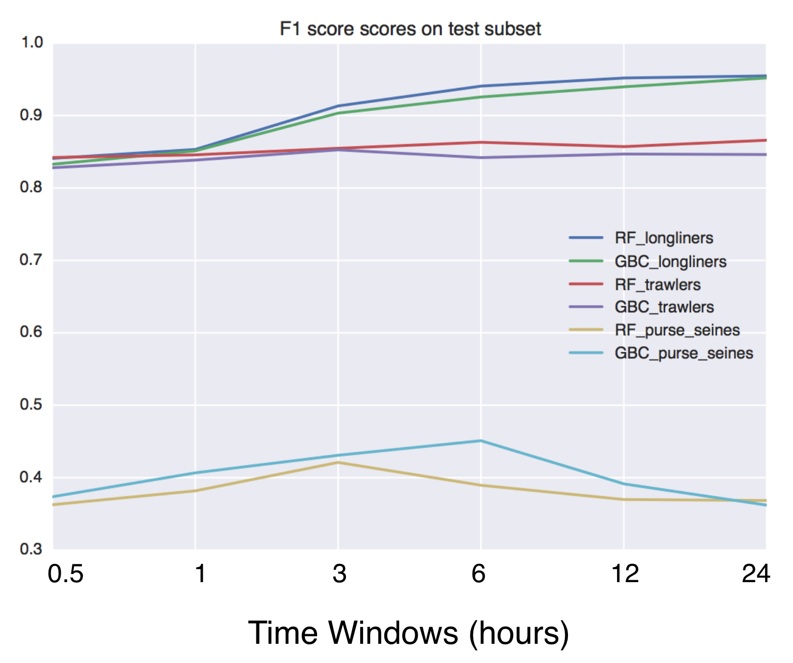
Using Global fishing watch's data to build a machine learning model that can identify illegal fishing and poaching activities through satellite and geo-location data.

Using Global fishing watch's data to build a machine learning model that can identify illegal fishing and poaching activities through satellite and geo-location data.

Script that allows to download data with satellite's orbit height and create CSV with their change in time.

Satellite orbit height β—Ύ Requirements Python = 3.8 Packages listen in reuirements.txt (run pip install -r requirements.txt) Account on Space Track β—Ύ

Helping data scientists better understand their datasets and models in text classification. With love from ServiceNow.

Azimuth, an open-source dataset and error analysis tool for text classification, with love from ServiceNow. Overview Azimuth is an open source applica

A package built to support working with spatial data using open source python

EarthPy EarthPy makes it easier to plot and manipulate spatial data in Python. Why EarthPy? Python is a generic programming language designed to suppo

GeoNode is an open source platform that facilitates the creation, sharing, and collaborative use of geospatial data.

Table of Contents What is GeoNode? Try out GeoNode Install Learn GeoNode Development Contributing Roadmap Showcase Most useful links Licensing What is

GebPy is a Python-based, open source tool for the generation of geological data of minerals, rocks and complete lithological sequences.

GebPy is a Python-based, open source tool for the generation of geological data of minerals, rocks and complete lithological sequences. The data can be generated randomly or with respect to user-defined constraints, for example a specific element concentration within minerals and rocks or the order of units within a complete lithological profile.

Tile Map Service and OGC Tiles API for QGIS Server

Tiles API Add tiles API to QGIS Server Tiles Map Service API OGC Tiles API Tile Map Service API - TMS The TMS API provides these URLs: /tms/? to get i

Zora is a python program that searches for GeoLocation info for given CIDR networks , with options to search with API or without API

Zora Zora is a python program that searches for GeoLocation info for given CIDR networks , with options to search with API or without API Installing a

Releases(v1.1)
  • v1.1(Oct 15, 2022)

  • v1.0(Jul 9, 2022)

    mmdb-server v1.0 released - an open source fast API server to lookup IP addresses for their geographic location. The server reached version 1.0 as many production servers are running flawlessly with this code. mmdb-server includes the geo-open database from CIRCL.

    Source code(tar.gz)
    Source code(zip)
  • v0.5(Feb 6, 2022)

    mmdb-server (the open and free geo IP server) version 0.5 released (2022-02-06) πŸ—ΊοΈ

    mmdb-server (the open and free geo IP server) version 0.5 released which includes the support for to load multiple MMDB files.

    A new GeoOpen database included to support AS number and AS description lookup.

    New

    • [multiple MMDB file support] MMDB server can now load a list of MMDB files + new GeoOpen file including ASN details added as example. [Alexandre Dulaunoy]

      GeoOpen files for country only -> https://cra.circl.lu/opendata/geo-open/mmdb-country/ GeoOpen files with country and ASN/ASN description -> https://cra.circl.lu/opendata/geo-open/mmdb-country-asn/

    • [db] Country-ASN db added. [Alexandre Dulaunoy]

    • [db] GeoOpen database updated. [Alexandre Dulaunoy]

    Changes

    • [doc] update the documentation and examples with the multiple sources. [Alexandre Dulaunoy]

    • [log] remove old debug. [Alexandre Dulaunoy]

    • [db] renamed. [Alexandre Dulaunoy]

    • [GeoOpen-country] updated. [Alexandre Dulaunoy]

    Other

    • Update README.md. [Alexandre Dulaunoy]
    Source code(tar.gz)
    Source code(zip)
  • v0.2(Jan 24, 2022)

    What's new in v0.2 (2022-01-24)

    New

    • [server] Add additional information about the country including average location, complete name and numeric code. [Alexandre Dulaunoy]

    • [mygeolookup] Query on root of the server will give the geo location of the remote IP address doing the query. [Alexandre Dulaunoy]

    Changes

    • [doc] update JSON output and CIRCL public service. [Alexandre Dulaunoy]

    • [server] display port. [Alexandre Dulaunoy]

    • [server] make port configurable. [Alexandre Dulaunoy]

    Source code(tar.gz)
    Source code(zip)
  • v0.1(Jan 23, 2022)

    mmdb-server is an open source fast API server to lookup IP addresses for their geographic location. The server can be used with any MaxMind DB File Format or file in the same format.

    mmdb-server includes a free and open GeoOpen-Country database for IPv4 and IPv6 addresses. The file GeoOpen-Country is generated on a regular basis from AS announces and their respective whois records.

    Installation

    Python 3.8+ is required to run the mmdb-server with some additional requirements.

    • pip3 install -r REQUIREMENTS
    • cp ./etc/server.conf.sample ./etc/server.conf
    • cd bin; python3 server.py

    Usage

    Lookup of an IP address

    curl -s http://127.0.0.1:8000/geolookup/188.65.220.25 | jq .

    [
      {
        "country": {
          "iso_code": "BE"
        },
        "meta": {
          "description": {
            "en": "Geo Open MMDB database - https://github.com/adulau/mmdb-server"
          },
          "build_db": "2022-01-23 16:13:05",
          "db_source": "GeoOpen-Country",
          "nb_nodes": 1156125
        }
      }
    ]
    

    $ curl -s http://127.0.0.1:8000/geolookup/2a02:21d0::68:69:25 | jq .

    [
      {
        "country": {
          "iso_code": "BE"
        },
        "meta": {
          "description": {
            "en": "Geo Open MMDB database - https://github.com/adulau/mmdb-server"
          },
          "build_db": "2022-01-23 16:13:05",
          "db_source": "GeoOpen-Country",
          "nb_nodes": 1156125
        }
      }
    ]
    

    Output format

    The output format is an array of JSON object (to support the ability to serve multiple geo location database). Each JSON object of the JSON array includes a meta and a country fields. The country give the geo graphic location of the IP address queried. The meta field includes the origin of the MMDB database which the the metadata.

    Source code(tar.gz)
    Source code(zip)
Owner
Alexandre Dulaunoy
Enjoy when human are using machines in unexpected ways. I break stuff and I do stuff.
Alexandre Dulaunoy
Use Mapbox GL JS to visualize data in a Python Jupyter notebook

Location Data Visualization library for Jupyter Notebooks Library documentation at https://mapbox-mapboxgl-jupyter.readthedocs-hosted.com/en/latest/.

Mapbox 620 Dec 15, 2022
WhiteboxTools Python Frontend

whitebox-python Important Note This repository is related to the WhiteboxTools Python Frontend only. You can report issues to this repo if you have pr

Qiusheng Wu 304 Dec 15, 2022
Download and process satellite imagery in Python using Sentinel Hub services.

Description The sentinelhub Python package allows users to make OGC (WMS and WCS) web requests to download and process satellite images within your Py

Sentinel Hub 659 Dec 23, 2022
Ingest and query genomic intervals from multiple BED files

Ingest and query genomic intervals from multiple BED files.

4 May 29, 2021
Python script that can be used to generate latitude/longitude coordinates for GOES-16 full-disk extent.

goes-latlon Python script that can be used to generate latitude/longitude coordinates for GOES-16 full-disk extent. 🌎 πŸ›°οΈ The grid files can be acces

Douglas Uba 3 Apr 06, 2022
Tool to display your current position and angle above your radar

πŸ›  Tool to display your current position and angle above your radar. As a response to the CS:GO Update on 1.2.2022, which makes cl_showpos a cheat-pro

Miko 6 Jan 04, 2023
scalable analysis of images and time series

thunder scalable analysis of image and time series analysis in python Thunder is an ecosystem of tools for the analysis of image and time series data

thunder-project 813 Dec 29, 2022
Open GeoJSON data on geojson.io

geojsonio.py Open GeoJSON data on geojson.io from Python. geojsonio.py also contains a command line utility that is a Python port of geojsonio-cli. Us

Jacob Wasserman 114 Dec 21, 2022
geemap - A Python package for interactive mapping with Google Earth Engine, ipyleaflet, and ipywidgets.

A Python package for interactive mapping with Google Earth Engine, ipyleaflet, and folium

Qiusheng Wu 2.4k Dec 30, 2022
GetOSM is an OpenStreetMap tile downloader written in Python that is agnostic of GUI frameworks.

GetOSM GetOSM is an OpenStreetMap tile downloader written in Python that is agnostic of GUI frameworks. It is used with tkinter by ProjPicker. Require

Huidae Cho 3 May 20, 2022
Blender addons to make the bridge between Blender and geographic data

Blender GIS Blender minimal version : 2.8 Mac users warning : currently the addon does not work on Mac with Blender 2.80 to 2.82. Please do not report

5.9k Jan 02, 2023
Global topography (referenced to sea-level) in a 10 arcminute resolution grid

Earth - Topography grid at 10 arc-minute resolution Global 10 arc-minute resolution grids of topography (ETOPO1 ice-surface) referenced to mean sea-le

Fatiando a Terra Datasets 1 Jan 20, 2022
Introduction to Geospatial Analysis in Python

Introduction to Geospatial Analysis in Python This repository is in support of a talk on geospatial data. Data To recreate all of the examples, the da

Dillon Gardner 6 Oct 19, 2022
Manage your XYZ Hub or HERE Data Hub spaces from Python.

XYZ Spaces for Python Manage your XYZ Hub or HERE Data Hub spaces and Interactive Map Layer from Python. FEATURED IN: Online Python Machine Learning C

HERE Technologies 30 Oct 18, 2022
Digital Earth Australia notebooks and tools repository

Repository for Digital Earth Australia Jupyter Notebooks: tools and workflows for geospatial analysis with Open Data Cube and xarray

Geoscience Australia 335 Dec 24, 2022
A part of HyRiver software stack for handling geospatial data manipulations

Package Description Status PyNHD Navigate and subset NHDPlus (MR and HR) using web services Py3DEP Access topographic data through National Map's 3DEP

Taher Chegini 5 Dec 14, 2022
List of Land Cover datasets in the GEE Catalog

List of Land Cover datasets in the GEE Catalog A list of all the Land Cover (or discrete) datasets in Google Earth Engine. Values, Colors and Descript

David Montero Loaiza 5 Aug 24, 2022
Mmdb-server - An open source fast API server to lookup IP addresses for their geographic location

mmdb-server mmdb-server is an open source fast API server to lookup IP addresses

Alexandre Dulaunoy 67 Nov 25, 2022
When traveling in the backcountry during winter time, updating yourself on current and recent weather data is important to understand likely avalanche danger.

Weather Data When traveling in the backcountry during winter time, updating yourself on current and recent weather data is important to understand lik

Trevor Allen 0 Jan 02, 2022
Python bindings and utilities for GeoJSON

geojson This Python library contains: Functions for encoding and decoding GeoJSON formatted data Classes for all GeoJSON Objects An implementation of

Jazzband 765 Jan 06, 2023