QLUSTER is a relative orbit design tool for formation flying satellite missions and space rendezvous scenarios

Related tags

GeolocationQLUSTER
Overview

https://raw.githubusercontent.com/sammmlow/QLUSTER/main/gui/qluster_logo.png

Project: QLUSTER
Github: https://github.com/sammmlow/QLUSTER
Documents: https://example.com/
Version: 0.1 (Unstable)

docs license

Author: Samuel Y. W. Low

linkedin orcid

QLUSTER

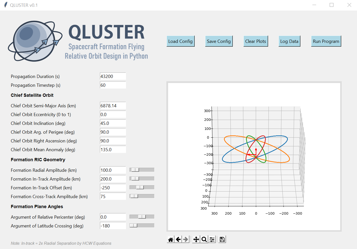
QLUSTER is a relative orbit design tool for formation flying satellite missions and space rendezvous scenarios, that I wrote in Python 3 for my own research and visualisation. It is currently unfinished (95%) but the core algorithm and app works. Here's an example snippet of the GUI where four deputy satellites are orbiting a single chief in LEO.

https://raw.githubusercontent.com/sammmlow/QLUSTER/main/gui/qluster_gui.png

I am open-sourcing it, as I would love to collaborate with you to improve on QLUSTER if you have any cool features to add-on in relation to the design, visualisation, and propagation of the relative astrodynamics!

To-Do List: Documentation, deputy orbit determination, logging of ephemeris etc.

Stretch-Goals: Relative orbit propagation for perturbed orbits, and computation of formation maintenance.


Installation and First Steps

First, clone this repository by running in your terminal (or Git Bash):

git clone https://github.com/sammmlow/QLUSTER.git

Then, just run the main qluster.py file in the main directory, and the GUI should pop up. Have fun!


Other Package Dependencies

To be written


Contact

If you have any queries feel free to reach out to me at:

[email protected]

linkedin orcid

Last Modified on 30-May-2021

Owner
Samuel Low
🌌 Space 🚀 Orbits 📡 Tech 🌏 Earth 🌳 Nature 🐢 Life ♥️
Samuel Low
GetOSM is an OpenStreetMap tile downloader written in Python that is agnostic of GUI frameworks.

GetOSM GetOSM is an OpenStreetMap tile downloader written in Python that is agnostic of GUI frameworks. It is used with tkinter by ProjPicker. Require

Huidae Cho 3 May 20, 2022
Rasterio reads and writes geospatial raster datasets

Rasterio Rasterio reads and writes geospatial raster data. Geographic information systems use GeoTIFF and other formats to organize and store gridded,

Mapbox 1.9k Jan 07, 2023
WhiteboxTools Python Frontend

whitebox-python Important Note This repository is related to the WhiteboxTools Python Frontend only. You can report issues to this repo if you have pr

Qiusheng Wu 304 Dec 15, 2022
User friendly Rasterio plugin to read raster datasets.

rio-tiler User friendly Rasterio plugin to read raster datasets. Documentation: https://cogeotiff.github.io/rio-tiler/ Source Code: https://github.com

372 Dec 23, 2022
Bacon - Band-limited Coordinate Networks for Multiscale Scene Representation

BACON: Band-limited Coordinate Networks for Multiscale Scene Representation Project Page | Video | Paper Official PyTorch implementation of BACON. BAC

Stanford Computational Imaging Lab 144 Dec 29, 2022
Computer Vision in Python

Mahotas Python Computer Vision Library Mahotas is a library of fast computer vision algorithms (all implemented in C++ for speed) operating over numpy

Luis Pedro Coelho 792 Dec 20, 2022
Starlite-tile38 - Showcase using Tile38 via pyle38 in a Starlite application

Starlite-Tile38 Showcase using Tile38 via pyle38 in a Starlite application. Repo

Ben 8 Aug 07, 2022
Cloud Optimized GeoTIFF creation and validation plugin for rasterio

rio-cogeo Cloud Optimized GeoTIFF (COG) creation and validation plugin for Rasterio. Documentation: https://cogeotiff.github.io/rio-cogeo/ Source Code

216 Dec 31, 2022
Manage your XYZ Hub or HERE Data Hub spaces from Python.

XYZ Spaces for Python Manage your XYZ Hub or HERE Data Hub spaces and Interactive Map Layer from Python. FEATURED IN: Online Python Machine Learning C

HERE Technologies 30 Oct 18, 2022
A Python framework for building geospatial web-applications

Hey there, this is Greppo... A Python framework for building geospatial web-applications. Greppo is an open-source Python framework that makes it easy

Greppo 304 Dec 27, 2022
Ingest and query genomic intervals from multiple BED files

Ingest and query genomic intervals from multiple BED files.

4 May 29, 2021
pure-Python (Numpy optional) 3D coordinate conversions for geospace ecef enu eci

Python 3-D coordinate conversions Pure Python (no prerequistes beyond Python itself) 3-D geographic coordinate conversions and geodesy. API similar to

Geospace code 292 Dec 29, 2022
Solving the Traveling Salesman Problem using Self-Organizing Maps

Solving the Traveling Salesman Problem using Self-Organizing Maps This repository contains an implementation of a Self Organizing Map that can be used

Diego Vicente 3.1k Dec 31, 2022
Raster-based Spatial Analysis for Python

🌍 xarray-spatial: Raster-Based Spatial Analysis in Python 📍 Fast, Accurate Python library for Raster Operations ⚡ Extensible with Numba ⏩ Scalable w

makepath 649 Jan 01, 2023
A Jupyter - Leaflet.js bridge

ipyleaflet A Jupyter / Leaflet bridge enabling interactive maps in the Jupyter notebook. Usage Selecting a basemap for a leaflet map: Loading a geojso

Jupyter Widgets 1.3k Dec 27, 2022
Track International space station with python

NASA-ISS-tracker Track International space station with python Modules import json import turtle import urllib.request import time import webbrowser i

Nikhil Yadav 8 Aug 12, 2021
Google maps for Jupyter notebooks

gmaps gmaps is a plugin for including interactive Google maps in the IPython Notebook. Let's plot a heatmap of taxi pickups in San Francisco: import g

Pascal Bugnion 747 Dec 19, 2022
WebGL2 powered geospatial visualization layers

deck.gl | Website WebGL2-powered, highly performant large-scale data visualization deck.gl is designed to simplify high-performance, WebGL-based visua

Vis.gl 10.5k Jan 08, 2023
A bot that tweets info and location map for new bicycle parking added to OpenStreetMap within a GeoJSON boundary.

Bike parking tweepy bot app A twitter bot app that searches for bicycle parking added to OpenStreetMap. Relies on AWS Lambda/S3, Python3, Tweepy, Flas

Angelo Trivisonno 1 Dec 19, 2021
Introduction to Geospatial Analysis in Python

Introduction to Geospatial Analysis in Python This repository is in support of a talk on geospatial data. Data To recreate all of the examples, the da

Dillon Gardner 6 Oct 19, 2022