A part of HyRiver software stack for accessing hydrology data through web services

Overview
https://raw.githubusercontent.com/cheginit/HyRiver-examples/main/notebooks/_static/pygeohydro_logo.png

JOSS

Package Description Status
PyNHD Navigate and subset NHDPlus (MR and HR) using web services Github Actions
Py3DEP Access topographic data through National Map's 3DEP web service Github Actions
PyGeoHydro Access NWIS, NID, WQP, HCDN 2009, NLCD, and SSEBop databases Github Actions
PyDaymet Access Daymet for daily climate data both single pixel and gridded Github Actions
AsyncRetriever High-level API for asynchronous requests with persistent caching Github Actions
PyGeoOGC Send queries to any ArcGIS RESTful-, WMS-, and WFS-based services Github Actions
PyGeoUtils Convert responses from PyGeoOGC's supported web services to datasets Github Actions

PyGeoHydro: Retrieve Geospatial Hydrology Data

PyPi Conda Version CodeCov Python Versions Downloads

CodeFactor black pre-commit Binder

Features

PyGeoHydro (formerly named hydrodata) is a part of HyRiver software stack that is designed to aid in watershed analysis through web services. This package provides access to some public web services that offer geospatial hydrology data. It has three main modules: pygeohydro, plot, and helpers.

The pygeohydro module can pull data from the following web services:

  • NWIS for daily mean streamflow observations (returned as a pandas.DataFrame or xarray.Dataset with station attributes),
  • Water Quality Portal for accessing current and historical water quality data from more than 1.5 million sites across the US,
  • NID for accessing both versions of the National Inventory of Dams web services,
  • HCDN 2009 for identifying sites where human activity affects the natural flow of the watercourse,
  • NLCD 2019 for land cover/land use, imperviousness, imperviousness descriptor, and canopy data,
  • SSEBop for daily actual evapotranspiration, for both single pixel and gridded data.

Also, it has two other functions:

  • interactive_map: Interactive map for exploring NWIS stations within a bounding box.
  • cover_statistics: Categorical statistics of land use/land cover data.

The plot module includes two main functions:

  • signatures: Hydrologic signature graphs.
  • cover_legends: Official NLCD land cover legends for plotting a land cover dataset.
  • descriptor_legends: Color map and legends for plotting an imperviousness descriptor dataset.

The helpers module includes:

  • nlcd_helper: A roughness coefficients lookup table for each land cover and imperviousness descriptor type which is useful for overland flow routing among other applications.
  • nwis_error: A dataframe for finding information about NWIS requests' errors.

Moreover, requests for additional databases and functionalities can be submitted via issue tracker.

You can find some example notebooks here.

You can also try using PyGeoHydro without installing it on your system by clicking on the binder badge. A Jupyter Lab instance with the HyRiver stack pre-installed will be launched in your web browser, and you can start coding!

Please note that since this project is in early development stages, while the provided functionalities should be stable, changes in APIs are possible in new releases. But we appreciate it if you give this project a try and provide feedback. Contributions are most welcome.

Moreover, requests for additional functionalities can be submitted via issue tracker.

Installation

You can install PyGeoHydro using pip after installing libgdal on your system (for example, in Ubuntu run sudo apt install libgdal-dev). Moreover, PyGeoHydro has an optional dependency for using persistent caching, requests-cache. We highly recommend installing this package as it can significantly speed up send/receive queries. You don't have to change anything in your code, since PyGeoHydro under-the-hood looks for requests-cache and if available, it will automatically use persistent caching:

$ pip install pygeohydro

Alternatively, PyGeoHydro can be installed from the conda-forge repository using Conda:

$ conda install -c conda-forge pygeohydro

Quick start

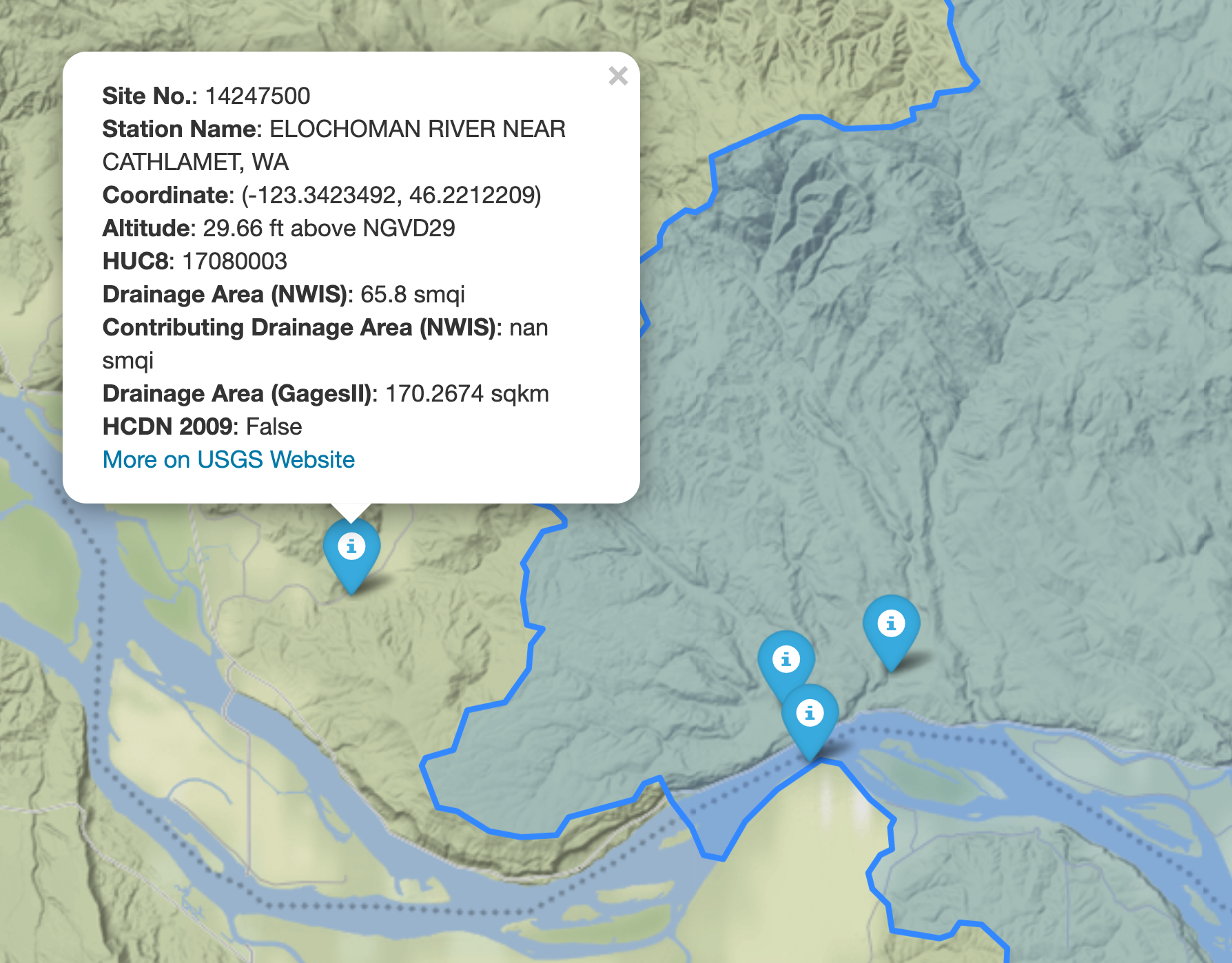
We can explore the available NWIS stations within a bounding box using interactive_map function. It returns an interactive map and by clicking on a station some of the most important properties of stations are shown.

import pygeohydro as gh

bbox = (-69.5, 45, -69, 45.5)
gh.interactive_map(bbox)
Interactive Map

We can select all the stations within this boundary box that have daily mean streamflow data from 2000-01-01 to 2010-12-31:

from pygeohydro import NWIS

nwis = NWIS()
query = {
    **nwis.query_bybox(bbox),
    "hasDataTypeCd": "dv",
    "outputDataTypeCd": "dv",
}
info_box = nwis.get_info(query)
dates = ("2000-01-01", "2010-12-31")
stations = info_box[
    (info_box.begin_date <= dates[0]) & (info_box.end_date >= dates[1])
].site_no.tolist()

Then, we can get the daily streamflow data in mm/day (by default the values are in cms) and plot them:

from pygeohydro import plot

qobs = nwis.get_streamflow(stations, dates, mmd=True)
plot.signatures(qobs)

By default, get_streamflow returns a pandas.DataFrame that has a attrs method containing metadata for all the stations. You can access it like so qobs.attrs. Moreover, we can get the same data as xarray.Dataset as follows:

qobs_ds = nwis.get_streamflow(stations, dates, to_xarray=True)

This xarray.Dataset has two dimensions: time and station_id. It has 10 variables including discharge with two dimensions while other variables that are station attitudes are one dimensional.

We can also get instantaneous streamflow data using get_streamflow. This method assumes that the input dates are in UTC time zone and returns the data in UTC time zone as well.

date = ("2005-01-01 12:00", "2005-01-12 15:00")
qobs = nwis.get_streamflow("01646500", date, freq="iv")

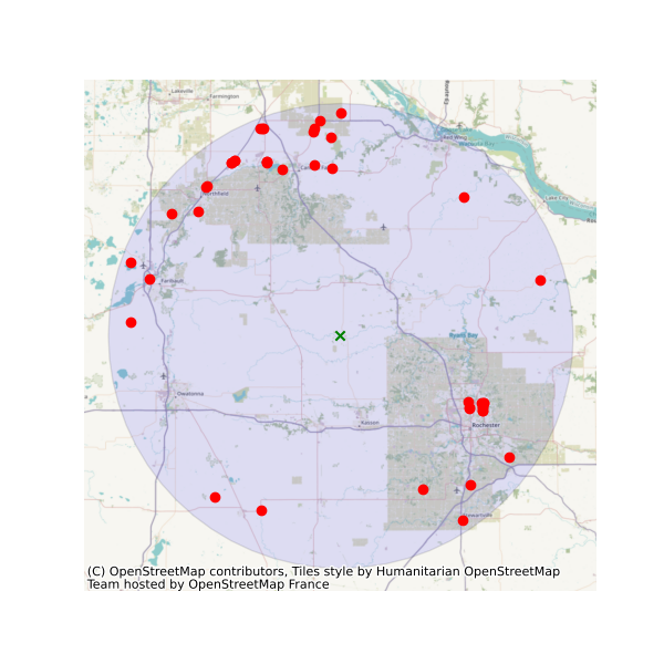
The WaterQuality has a number of convenience methods to retrieve data from the web service. Since there are many parameter combinations that can be used to retrieve data, a general method is also provided to retrieve data from any of the valid endpoints. You can use get_json to retrieve stations info as a geopandas.GeoDataFrame or get_csv to retrieve stations data as a pandas.DataFrame. You can construct a dictionary of the parameters and pass it to one of these functions. For more information on the parameters, please consult the Water Quality Data documentation. For example, let's find all the stations within a bounding box that have Caffeine data:

from pynhd import WaterQuality

bbox = (-92.8, 44.2, -88.9, 46.0)
kwds = {"characteristicName": "Caffeine"}
wq = WaterQuality()
stations = wq.station_bybbox(bbox, kwds)

Or the same criterion but within a 30-mile radius of a point:

stations = wq.station_bydistance(-92.8, 44.2, 30, kwds)

Then we can get the data for all these stations the data like this:

sids = stations.MonitoringLocationIdentifier.tolist()
caff = wq.data_bystation(sids, kwds)
Water Quality

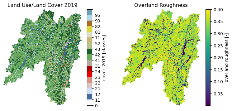
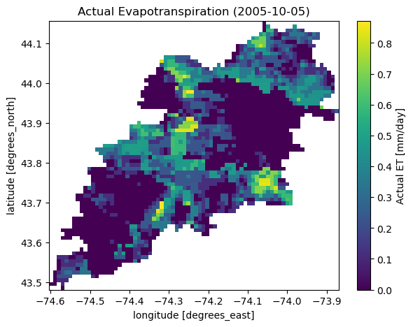
Moreover, we can get land use/land cove data using nlcd function, percentages of land cover types using cover_statistics, and actual ET with ssebopeta_bygeom:

from pynhd import NLDI

geometry = NLDI().get_basins("01031500").geometry[0]
lulc = gh.nlcd(geometry, 100, years={"cover": [2016, 2019]})
stats = gh.cover_statistics(lulc.cover_2016)
eta = gh.ssebopeta_bygeom(geometry, dates=("2005-10-01", "2005-10-05"))
Land Use/Land Cover Actual ET

Additionally, we can pull all the US dams data using NID. Let's get dams that are within this bounding box and have a maximum storage larger than 200 acre-feet.

nid = NID()
dams = nid.bygeom(bbox, "epsg:4326", sql_clause="MAX_STORAGE > 200")

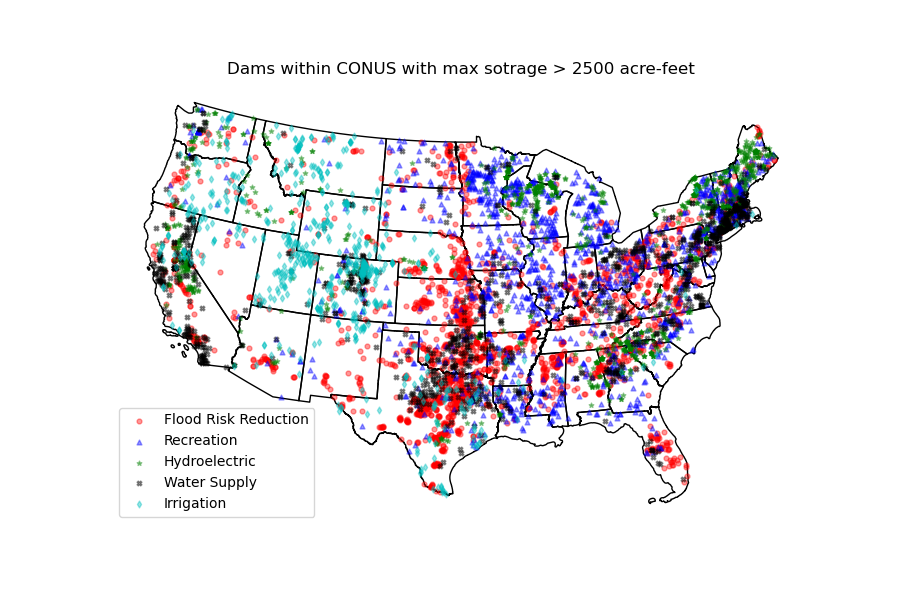
We can get all the dams within CONUS using NID and plot them:

import geopandas as gpd

world = gpd.read_file(gpd.datasets.get_path("naturalearth_lowres"))
conus = world[world.name == "United States of America"].geometry.iloc[0][0]
conus_dams = nid.bygeom(conus, "epsg:4326")
Dams

Contributing

Contributions are very welcomed. Please read CONTRIBUTING.rst file for instructions.

Credits

This package was created based on the audreyr/cookiecutter-pypackage project template.

Comments
  • NLCD by location

    NLCD by location

    For an aviation use case - "Where did the drone launch?' - I'd like to get the land use for a lot of points in the U.S.

    A similar use case that I use is "What is the elevation at a particular point?" To answer this, I run an https://open-elevation.com/ docker instance and use the API to pass in thousands of lat/lon pairs. It returns the pairs with the elevation and I take the elevation and add it as a column to my dataframe.

    A good solution would be a function that operated on a local copy of the NLCD database, took lat/lon pairs, and returned the text description of the land use. The pairs could be distinct lat / lon values or possibly a geodataframe with one or more points.

    If this function was vectorized and could process large numbers of points quickly that would be a bonus but not necessary.

    The best option I could come up with involved setting a bounding box around each point. (See Discussions for details.)

    opened by kovar-ursa 17
  • Change to epsg:4269 in WaterData request

    Change to epsg:4269 in WaterData request

    It looks like the USGS GeoServer layers were changed in the last 24 hours!! They no longer support epsg:900913 (web mercator), and now only accept epsg:4269. NWIS.get_info now fails because of this. I updated the epsg code on the WaterData call, and that should fix it. I've run WaterData calls with epsg:4269 on other layers (FYI, huc12) and it works.

    • [ ] Closes #xxxx
    • [ ] Tests added and passed make coverage
    • [ ] Passes make lint
    • [ ] User visible changes (including notable bug fixes) are documented in HISTORY.rst
    • [ ] After adding new functions/methods ran make apidocs
    opened by emiliom 13
  • NWIS data retrieval enhancement ideas

    NWIS data retrieval enhancement ideas

    It would be great to be able to set some parameter to ensure that the retrieved NWIS data are in UTC.

    Also it would be nice to have the ability to return the data (along with metadata such as units!) as an xarray dataset instead of a pandas dataframe.

    There is an example NWIS code here by @dnowacki-usgs that optionally returns an xarray dataset.

    enhancement 
    opened by rsignell-usgs 8
  • get_streamflow() to_xarray inconsistent dtypes

    get_streamflow() to_xarray inconsistent dtypes

    What happened: Repeated calls to get_streamflow() returning an xarray DataSet have different dtypes for some fields (notably, strings).

    What you expected to happen: The returned encodings/schema would be consistent for all calls, and match the internal schema of the NWIS database from which the data is fetched.

    Minimal Complete Verifiable Example:

    from pygeohydro import NWIS
    nwis=NWIS()
    DATE_RANGE=("2020-01-01", "2020-12-31")
    site_A = nwis.get_streamflow('USGS-402114105350101', DATE_RANGE, to_xarray=True )
    site_B = nwis.get_streamflow('USGS-02277600', DATE_RANGE, to_xarray=True )
    
    assert site_A['station_nm'].dtype == site_B['station_nm'].dtype
    ## fails
    
    assert site_A['alt_datum_cd'].dtype == site_B['alt_datum_cd'].dtype
    ## fails
    

    Anything else we need to know?: This has come up for me as I try to fetch streamflow data one gage at a time as part of a parallelized workflow -- each worker fetches one streamgage, manipulates it, then appends to a common dataset (in my case, a zarr store). The common zarr store was templated using NWIS.get_streamflow() data, which established the 'standard' dtypes.

    The dtypes for these particular fields (station_nm and alt_datum_cd) are unicode strings, with the length of the string (and the dtype) being that of the returned data for a given request. That is, the dtype for Site_A's alt_datum_cd (above) is '<U6' because the data happens to be 6 chars for that gage. For Site_B's alt_datum_cd, the dtype is '<U1'. It isn't just that the string is shorter, the dtype is different, which causes the zarr write to fail.

    I can work around this by re-casting in the case of these two strings:

    Site_B['alt_datum_cd'] = xr.DataArray(data=Site_B['alt_datum_cd'].values.astype('<U6'), dims='gage_id')
    

    But in the case of the station name field, I don't know what the max length might be from the database. I can cast to '<U46' (the dtype for Site_A's station_nm), but other gages may have longer names, which will be truncated when cast to this dtype.

    It would be useful to have get_streamflow() return the same string encoding/dtype in all cases, so that separate calls can be treated identically.

    Environment:

    Output of pygeohydro.show_versions()
    INSTALLED VERSIONS
    ------------------
    commit: None
    python: 3.9.13 | packaged by conda-forge | (main, May 27 2022, 16:56:21) 
    [GCC 10.3.0]
    python-bits: 64
    OS: Linux
    OS-release: 5.4.181-99.354.amzn2.x86_64
    machine: x86_64
    processor: x86_64
    byteorder: little
    LC_ALL: C.UTF-8
    LANG: C.UTF-8
    LOCALE: en_US.UTF-8
    libhdf5: 1.12.2
    libnetcdf: 4.8.1
    aiodns: 3.0.0
    aiohttp: 3.8.3
    aiohttp-client-cache: 0.7.3
    aiosqlite: 0.17.0
    async-retriever: 0.3.6
    bottleneck: 1.3.5
    brotli: installed
    cchardet: 2.1.7
    click: 8.0.2
    cytoolz: 0.12.0
    dask: 2022.04.2
    defusedxml: 0.7.1
    folium: 0.13.0
    geopandas: 0.11.1
    lxml: 4.9.1
    matplotlib: 3.4.3
    netCDF4: 1.6.0
    networkx: 2.8.7
    numpy: 1.23.3
    owslib: 0.27.2
    pandas: 1.4.2
    py3dep: 0.13.6
    pyarrow: 9.0.0
    pydantic: 1.10.2
    pydaymet: 0.13.6
    pygeohydro: 0.13.6
    pygeoogc: 0.13.6
    pygeos: 0.13
    pygeoutils: 0.13.6
    pynhd: 0.13.6
    pyproj: 3.4.0
    pytest: None
    pytest-cov: None
    rasterio: 1.3.2
    requests: 2.28.1
    requests-cache: 0.9.6
    richdem: None
    rioxarray: 0.12.2
    scipy: 1.9.1
    shapely: 1.8.4
    tables: 3.7.0
    ujson: 5.5.0
    urllib3: 1.26.11
    xarray: 2022.9.0
    xdist: None
    yaml: 5.4.1
    
    opened by gzt5142 6
  • Example code for NWIS query does not work

    Example code for NWIS query does not work

    What happened: Running the example code to generate a list of NWIS sites throws the following error 'NWIS' object has no attribute 'query_bybox'

    Minimal Complete Verifiable Example:

    from pygeohydro import NWIS
    
    nwis = NWIS()
    query = {
        **nwis.query_bybox(bbox),
        "hasDataTypeCd": "dv",
        "outputDataTypeCd": "dv",
    }
    info_box = nwis.get_info(query)
    dates = ("2000-01-01", "2010-12-31")
    stations = info_box[
        (info_box.begin_date <= dates[0]) & (info_box.end_date >= dates[1])
    ].site_no.tolist()
    

    Environment:

    Output of pygeohydro.show_versions() INSTALLED VERSIONS

    commit: None python: 3.8.13 | packaged by conda-forge | (default, Mar 25 2022, 06:04:10) [GCC 10.3.0] python-bits: 64 OS: Linux OS-release: 4.15.0-167-generic machine: x86_64 processor: x86_64 byteorder: little LC_ALL: None LANG: en_US LOCALE: en_US.ISO8859-1 libhdf5: 1.12.1 libnetcdf: 4.8.1

    aiodns: 3.0.0 aiohttp: 3.8.1 aiohttp-client-cache: 0.7.1 aiosqlite: 0.17.0 async-retriever: 0.3.3 bottleneck: 1.3.4 brotli: installed cchardet: 2.1.7 click: 6.7 cytoolz: 0.11.2 dask: 2022.6.1 defusedxml: 0.7.1 folium: 0.12.1.post1 geopandas: 0.11.0 lxml: 4.8.0 matplotlib: 3.4.3 netCDF4: 1.6.0 networkx: 2.8.4 numpy: 1.23.0 owslib: 0.25.0 pandas: 1.4.3 py3dep: 0.13.1 pyarrow: 6.0.1 pydantic: 1.9.1 pydaymet: 0.13.1 pygeohydro: 0.13.2 pygeoogc: 0.13.2 pygeos: 0.12.0 pygeoutils: 0.13.2 pynhd: 0.13.2 pyproj: 3.3.0 pytest: None pytest-cov: None rasterio: 1.2.10 requests: 2.28.1 requests-cache: 0.9.4 richdem: 0.3.4 rioxarray: 0.11.1 scipy: 1.8.1 shapely: 1.8.2 tables: 3.7.0 ujson: 5.3.0 urllib3: 1.26.9 xarray: 2022.3.0 xdist: None yaml: 6.0```

    </details>
    
    opened by onnyyonn 6
  • Shapely import issue on Darwin

    Shapely import issue on Darwin

    • Hydrodata version: 0.4.4
    • Python version: 3.7.7
    • Operating System: macOS 10.14.4
    • [x] Using Conda

    Description

    I found an issue when importing any from shapely.geometry packages on Shapely 1.7.0. Getting the following:

    File "/Users/austinraney/miniconda3/envs/hydrodata/lib/python3.7/site-packages/shapely/geos.py", line 62, in load_dll
        libname, fallbacks or []))
    OSError: Could not find lib cxx or load any of its variants [].
    

    I found the related issue and it seems that the PR fixed it (I tested the change on my system at least). Just something to know about. Hopefully they will update the package on PyPI soon.

    What I Did

    python -c "from shapely.geometry import Point"
    
    opened by aaraney 6
  • Did something change with NWIS?

    Did something change with NWIS?

    What happened: my NWIS example stopped working

    What you expected to happen:

    Minimal Complete Verifiable Example:

    from pygeohydro import NWIS
    
    nwis = NWIS()
    
    start = '1979-02-01T01:00:00'
    stop =  '2020-12-31T23:00:00'
    
    sta = ['USGS-01030350', 'USGS-01030500']
    
    ds_obs = nwis.get_streamflow(sta, (start,stop), to_xarray=True)
    

    I tried pygeohydro versions 0.13.0 and 0.13.1

    opened by rsignell-usgs 4
  • Monthly & annual SSEBop ET available via OPenDAP from USGS THREDDS server

    Monthly & annual SSEBop ET available via OPenDAP from USGS THREDDS server

    Re: https://github.com/cheginit/hydrodata/blob/master/hydrodata/datasets.py#L854

    Since there's still no web service available for subsetting SSEBop, the data first needs to be downloaded for the requested period then it is masked by the region of interest locally. Therefore, it's not as fast as other functions and the bottleneck could be the download speed.

    FYI, there is an OPeNDAP endpoint available from the USGS CIDA THREDDS server (managed by David Blodgett, I think) for monthly and annual SSEBop ET -- though not daily:

    • THREDDS catalog page for monthly data: https://cida.usgs.gov/thredds/catalog.html?dataset=cida.usgs.gov/ssebopeta/monthly
    • THREDDS OPeNDAP endpoint: https://cida.usgs.gov/thredds/dodsC/ssebopeta/monthly
    opened by emiliom 4
  • Theoretical meta source class

    Theoretical meta source class

    To preface this, I don't expect this to be pulled in, it was more of a way to showcase an idea and get us thinking. Admittedly, this could be unnecessary for a project of this size where there are 5-10 different datasources, so just no that is too much boilerplate code is also a fine response lol.

    So, with that being said, I went through datasets.py and it seems like there is a little bit of code redundancy or maybe just thought redundancy? The platform you have built seems to have a ton of potential to have additional datasets added, so with that in mind I wrote a sort of meta class for sources.

    Purpose

    Set expectations for future collaborators and provide a framework for adding in other datasets. Basically, let's build a framework for what a source should have and the methods it must have.

    This class would be inherited by all other source classes and can either use or override the existing methods in the meta source class to keep a consistent namespace.

    /sources/__init__.py can be used to control the public API that a user will interface with.

    Known problems/limitations

    All datasources are not created equal, or at least they may have differing kinds of data (gridded, point, tabular, etc.) so creating a meta class might need to be divided into a structured hierarchy, where there is a root meta class that is inherited by two to three provider type classes which each inherit the root meta class.

    For example, the root meta class would have things that all providers have, their name, url, citation, base_url a __str__ method, plus any other general attributes all sources WILL have. Then a meta gridded class could hold class methods like bybox and bygeom and this class would be inherited by gridded data sources. It should be noted that sources that support multiple data types could utilize multi inheritance and inherit two or more meta classes (i.e. meta gridded and meta tabular).

    What I did

    The DataSource class is the meta class if you will. There are two examples of using DataSource, the ssebopeta will probably be a more interesting example. I didn't test the bygeom class method, but I think it should work or be very close. Just mainly wanted to showcase the idea more than anything else.

    enhancement 
    opened by aaraney 4
  • NHDPlus Implementation

    NHDPlus Implementation

    Before I offer my suggestion, I may be missing the utility of shipping the NHD with the repo. With that in mind and if you don't mind elaborating later, what are your thought on moving away from shipping the NHDPlus dataset to users and instead relying on the USGS's api to verify and obtain gauge metadata? It should be a straight forward call that doesn't require a key.

    enhancement 
    opened by aaraney 4
  • Missing examples/tutorial.ipynb

    Missing examples/tutorial.ipynb

    Description

    Its seems examples/tutorial.ipynb which was added on commit 68fe37f has been removed. What are the future plans for examples/ and if you would like me to write something up, do you have features in mind you would like me to showcase?

    documentation 
    opened by aaraney 4
  • Add support for SensorThings

    Add support for SensorThings

    Is your feature request related to a problem? Please describe. No. USGS water data has a new web service called SensorThings that provides access to many USGS datasets.

    Describe the solution you'd like A demo repository of its initial implementation is here.

    Describe alternatives you've considered N/A

    Additional context N/A

    opened by cheginit 0
Releases(v0.13.8)
  • v0.13.8(Dec 9, 2022)

    Release Notes

    New Features

    • Add a function called huc_wb_full that returns the full watershed boundary GeoDataFrame of a given HUC level. If only a subset of HUCs is needed the pygeohydro.WBD class should be used. The full dataset is downloaded from the National Maps' WBD staged products.
    • Add a new function called irrigation_withdrawals for retrieving estimated monthly water use for irrigation by 12-digit hydrologic unit in the CONUS for 2015 from ScienceBase.
    • Add a new property to NID, called data_units for indicating the units of NID dataset variables.
    • The get_us_states now accepts conus as a subset_key which is equivalent to contiguous.

    Internal Changes

    • Add get_us_states to __init__ file, so it can be loaded directly, e.g., gh.get_us_states("TX").
    • Modify the codebase based on Refurb suggestions.
    • Significant performance improvements in NWIS.get_streamflow especially for large requests by refactoring the timezone handling.

    Bug Fixes

    • Fix the dam types and purposes mapping dictionaries in NID class.
    Source code(tar.gz)
    Source code(zip)
  • v0.13.7(Nov 5, 2022)

    Release Notes

    New Features

    • Add a two new function for retrieving soil properties across the US:
      • soil_properties: Porosity, available water capacity, and field capacity,
      • soil_gnatsgo: Soil properties from the gNATSGO database.
    • Add a new help function called state_lookup_table for getting a lookup table of US states and their counties. This can be particularly useful for mapping the digit state_cd and county_cd that NWIS returns to state names/codes.
    • Add support for getting individual state geometries using get_us_states function by passing their two letter state code. Also, use TIGER 2022 data for the US states and counties instead of TIGER 2021.

    Internal Changes

    • Remove proplot as a dependency and use matplotlib instead.
    Source code(tar.gz)
    Source code(zip)
  • v0.13.6(Aug 30, 2022)

  • v0.13.5(Aug 29, 2022)

    Release Notes

    Breaking Changes

    • Append "Error" to all exception classes for conforming to PEP-8 naming conventions.
    • Deprecate ssebopeta_byloc since it's been replaced with ssebopeta_bycoords since version 0.13.0.

    Internal Changes

    • Bump the minimum versions of pygeoogc and pygeoutils to 0.13.5 and that of async-retriever to 0.3.5.
    Source code(tar.gz)
    Source code(zip)
  • v0.13.3(Jul 31, 2022)

    Release Notes

    New Features

    • Add a new argument to NID.inventory_byid class for staging the entire NID dataset prior to inventory queries. There a new public method called NID.stage_nid_inventory that can be used to download the entire NID dataset and save it as a feather file. This is useful inventory queries with large number of IDs and is much more efficient than querying the NID web service.

    Bug Fixes

    • The background value in cover_statistics function should have been 127 not 0. Also, dropped the background value from the return statistics.
    Source code(tar.gz)
    Source code(zip)
  • v0.13.2(Jun 14, 2022)

    Release Notes

    Breaking Changes

    • Set the minimum supported version of Python to 3.8 since many of the dependencies such as xarray, pandas, rioxarray have dropped support for Python 3.7.

    Internal Changes

    • Remove USGS prefixes from the input station IDs in NWIS.get_streamflow function. Also, check if the remaining parts of the IDs are all digits and throw an exception if otherwise. Additionally, make sure that IDs have at least 8 chars by adding leading zeros (:issue_hydro:[99]{.title-ref}).
    • Use micromamba for running tests and use nox for linting in CI.
    Source code(tar.gz)
    Source code(zip)
  • v0.13.1(Jun 12, 2022)

    Release Notes

    New Features

    • Add a new function called get_us_states to the helpers module for obtaining a GeoDataFrame of the US states. It has an optional argument for returning the contiguous states, continental states, commonwealths states, or US territories. The data are retrieved from the Census' Tiger 2021 database.
    • In the NID class keep the valid_fields property as a pandas.Series instead of a list, so it can be searched easier via its str accessor.

    Internal Changes

    • Refactor the plot.signatures function to use proplot instead of matplotlib.
    • Improve performance of NWIS.get_streamflow by not validating the layer name when instantiating the WaterData class. Also, make the function more robust by checking if streamflow data is available for each station and throw a warning if not.

    Bug Fixes

    • Fix an issue in NWIS.get_streamflow where -9999 values were not being filtered out. According to NWIS, these values are reserved for ice-affected data. This fix sets these values to numpy.nan.
    Source code(tar.gz)
    Source code(zip)
  • v0.13.0(Apr 4, 2022)

    Release Notes

    New Features

    • Add a new flag to nlcd_* functions called ssl for disabling SSL verification.
    • Add a new function called get_camels for getting the CAMELS dataset. The function returns a geopandas.GeoDataFrame that includes basin-level attributes for all 671 stations in the dataset and a xarray.Dataset that contains streamflow data for all 671 stations and their basin-level attributes.
    • Add a new function named overland_roughness for getting the overland roughness values from land cover data.
    • Add a new class called WBD for getting watershed boundary (HUC) data.
    from pygeohydro import WBD
    
    wbd = WBD("huc4")
    hudson = wbd.byids("huc4", ["0202", "0203"])
    

    Breaking Changes

    • Remove caching-related arguments from all functions since now they can be set globally via three environmental variables:

      • HYRIVER_CACHE_NAME: Path to the caching SQLite database.
      • HYRIVER_CACHE_EXPIRE: Expiration time for cached requests in seconds.
      • HYRIVER_CACHE_DISABLE: Disable reading/writing from/to the cache file.

      You can do this like so:

    import os
    
    os.environ["HYRIVER_CACHE_NAME"] = "path/to/file.sqlite"
    os.environ["HYRIVER_CACHE_EXPIRE"] = "3600"
    os.environ["HYRIVER_CACHE_DISABLE"] = "true"
    

    Internal Changes

    • Write nodata attribute using rioxarray in nlcd_bygeom since the clipping operation of rioxarray uses this value as the fill value.
    Source code(tar.gz)
    Source code(zip)
  • v0.12.4(Feb 4, 2022)

    Release Notes

    Internal Changes

    • Return a named tuple instead of a dict of percentages in the cover_statistics function. It makes accessing the values easier.
    • Add pycln as a new pre-commit hooks for removing unused imports.
    • Remove time zone info from the inputs to plot.signatures to avoid issues with the matplotlib backend.

    Bug Fixes

    • Fix an issue in plot.signatures where the new matplotlib version requires a numpy array instead of a pandas.DataFrame.
    Source code(tar.gz)
    Source code(zip)
  • v0.12.3(Jan 15, 2022)

    Release Notes

    Bug Fixes

    • Replace no data values of data in ssebopeta_bygeom with np.nan before converting it to mm/day.
    • Fix an inconsistency issue with CRS projection when using UTM in nlcd_*. Use EPSG:3857 for all reprojections and get the data from NLCD in the same projection. (:issue_hydro:[85]{.title-ref})
    • Improve performance of nlcd_* functions by reducing number of service calls.

    Internal Changes

    • Add type checking with typeguard and fix type hinting issues raised by typeguard.
    • Refactor show_versions to ensure getting correct versions of all dependencies.
    Source code(tar.gz)
    Source code(zip)
  • v0.12.2(Dec 31, 2021)

    Release Notes

    New Features

    • The NWIS.get_info now returns a geopandas.GeoDataFrame instead of a pandas.DataFrame.

    Bug Fixes

    • Fix a bug in NWIS.get_streamflow where the drainage area might not be computed correctly if target stations are not located at the outlet of their watersheds.
    Source code(tar.gz)
    Source code(zip)
  • v0.12.1(Dec 31, 2021)

    Release Notes

    Internal Changes

    • Use the three new ar.retrieve_* functions instead of the old ar.retrieve function to improve type hinting and to make the API more consistent.

    Bug Fixes

    • Fix an in issue with NWIS.get_streamflow where time zone of the data was not being correctly determined when it was US specific abbreviations such as CST.
    Source code(tar.gz)
    Source code(zip)
  • v0.12.0(Dec 28, 2021)

    Release Notes

    New Features

    • Add support for getting instantaneous streamflow from NWIS in addition to the daily streamflow by adding freq argument to NWIS.get_streamflow that can be either iv or dv. The default is dv to retain the previous behavior of the function.
    • Convert the time zone of the streamflow data to UTC.
    • Add attributes of the requested stations as attrs parameter to the returned pandas.DataFrame. (:issue_hydro:[75]{.title-ref})
    • Add a new flag to NWIS.get_streamflow for returning the streamflow as xarray.Dataset. This dataset has two dimensions; time and station_id. It has ten variables which includes discharge and nine other station attributes. (:issue_hydro:[75]{.title-ref})
    • Add drain_sqkm from GagesII to NWIS.get_info.
    • Show drain_sqkm in the interactive map generated by interactive_map.
    • Add two new functions for getting NLCD data; nlcd_bygeom and nlcd_bycoords. The new nlcd_bycoords function returns a geopandas.GeoDataFrame with the NLCD layers as columns and input coordinates, which should be a list of (lon, lat) tuples, as the geometry column. Moreover, The new nlcd_bygeom function now accepts a geopandas.GeoDataFrame as the input. In this case, it returns a dict with keys as indices of the input geopandas.GeoDataFrame. (:issue_hydro:[80]{.title-ref})
    • The previous nlcd function is being deprecated. For now, it calls nlcd_bygeom internally and retains the old behavior. This function will be removed in future versions.

    Breaking Changes

    • Set the request caching's expiration time to never expire. Add two flags to all functions to control the caching: expire_after and disable_caching.
    • Replace NID class with the new RESTful-based web service of National Inventory of Dams. The new NID service is very different from the old one, so this is considered a breaking change.

    Internal Changes

    • Improve exception handling in NWIS.get_info when NWIS returns an error message rather than 500s web service error.
    • The NWIS.get_streamflow function now checks if the site info dataset contains any duplicates. Therefore, all the remaining station numbers will be unique. This prevents an issue with setting attrs where duplicate indexes cause an exception when being converted to a dict. (:issue_hydro:[75]{.title-ref})
    • Add all the missing types so mypy --strict passes.
    Source code(tar.gz)
    Source code(zip)
  • v0.11.4(Nov 24, 2021)

    Release Notes

    New Features

    • Add support for the Water Quality Portal Web Services. (:issue_hydro:[72]{.title-ref})
    • Add support for two version of NID web service. The original NID web service is considered version 2 and the new NID is considered version 3. You can pass the version number to the NID like so NID(2). The default version is 2.

    Bug Fixes

    • Fix an issue with background percentage calculation in cover_statistics.
    Source code(tar.gz)
    Source code(zip)
  • v0.11.3(Nov 12, 2021)

    Release Notes

    New Features

    • Use a new MapService for National Inventory of Dams (NID).

    Internal Changes

    • Use importlib-metadata for getting the version insead of pkg_resources to decrease import time as discussed in this issue.
    Source code(tar.gz)
    Source code(zip)
  • v0.11.2(Jul 31, 2021)

    Release Notes

    Bug Fixes

    • Refactor cover_statistics to address an issue with wrong category names and also improve performance for large datasets by using numpy's functions.
    • Fix an issue with detecting wrong number of stations in NWIS.get_streamflow. Also, improve filtering stations that their start/end date don't match the user requested interval.
    Source code(tar.gz)
    Source code(zip)
  • v0.11.1(Jul 31, 2021)

    Release Notes

    The highlight of this release is adding support for NLCD 2019 and singnificant improvements in NWIS support.

    New Features

    • Add support for the recently released version of NLCD (2019), including the impervious descriptor layer. Highlights of the new database are:

      NLCD 2019 now offers land cover for years 2001, 2004, 2006, 2008, > 2011, 2013, 2016, 2019, and impervious surface and impervious > descriptor products now updated to match each date of land cover. > These products update all previously released versions of > landcover and impervious products for CONUS (NLCD 2001, NLCD 2006, > NLCD 2011, NLCD 2016) and are not directly comparable to previous > products. NLCD 2019 land cover and impervious surface product > versions of previous dates must be downloaded for proper > comparison. NLCD 2019 also offers an impervious surface descriptor > product that identifies the type of each impervious surface pixel. > This product identifies types of roads, wind tower sites, building > locations, and energy production sites to allow deeper analysis of > developed features. > > -- MRLC

    • Add support for all the supported regions of NLCD database (CONUS, AK, HI, and PR).

    • Add support for passing multiple years to the NLCD function, like so {"cover": [2016, 2019]}.

    • Add plot.descriptor_legends function to plot the legend for the impervious descriptor layer.

    • New features in NWIS class are:

      * Remove query_* methods since it's not convenient to pass them directly as a dictionary.

      * Add a new function called get_parameter_codes to query parameters and get information about them.

      * To decrease complexity of get_streamflow method add a new private function to handle some of the tasks.

      • For handling more of NWIS's services make retrieve_rdb more general.
    • Add a new argument called nwis_kwds to interactive_map so any NWIS specific keywords can be passed for filtering stations.

    • Improve exception handling in get_info method and simplify and improve its performance for getting HCDN.

    Internal Changes

    • Migrate to using AsyncRetriever for handling communications with web services.
    Source code(tar.gz)
    Source code(zip)
  • v0.11.0(Jun 20, 2021)

    Release Notes

    Breaking Changes

    • Drop support for Python 3.6 since many of the dependencies such as xarray and pandas have done so.
    • Remove get_nid and get_nid_codes functions since NID now has a ArcGISRESTFul service.

    New Features

    • Add a new class called NID for accessing the recently released National Inventory of Dams web service. This service is based on ArcGIS's RESTful service. So now the user just need to instantiate the class like so NID() and with three methods of AGRBase class, the user can retrieve the data. These methods are: bygeom, byids, and bysql. Moreover, it has an attrs property that includes descriptions of the database fields with their units.
    • Refactor NWIS.get_info to be more generic by accepting any valid queries that are documented at USGS Site Web Service.
    • Allow for passing a list of queries to NWIS.get_info and use async_retriever that significantly improves the network response time.
    • Add two new flags to interactive_map for limiting the stations to those with daily values (dv=True) and/or instantaneous values (iv=True). This function now includes a link to stations webpage on USGS website.

    Internal Changes

    • Use persistent caching for all send/receive requests that can significantly improve the network response time.
    • Explicitly include all the hard dependencies in setup.cfg.
    • Refactor interactive_map and NWIS.get_info to make them more efficient and reduce their code complexity.
    Source code(tar.gz)
    Source code(zip)
  • v0.10.2(Mar 27, 2021)

  • v0.10.1(Mar 6, 2021)

  • v0.10.0(Mar 6, 2021)

  • v0.9.2(Mar 3, 2021)

  • v0.9.1(Feb 22, 2021)

  • v0.9.0(Feb 17, 2021)

  • v0.8.0(Dec 7, 2020)

  • v0.2.0(Dec 7, 2020)

  • v0.7.3-beta(Sep 2, 2020)

  • 0.7.2(Aug 18, 2020)

    Enhancements

    • Replaced simplejson with orjson to speed-up JSON operations.
    • Explicitly sort the time dimension of the ssebopeta_bygeom function.

    Bug fixes

    • Fix an issue with the nlcd function where high-resolution requests fail.
    Source code(tar.gz)
    Source code(zip)
  • v0.7.1(Aug 14, 2020)

    This is a bug fix that addresses the nlcd function issue where not all None layers are dropped. Also, a new flag called title_ypos was added to the plot.signatures function for adjusting the vertical position of the supertitle which is useful for multi-line titles.

    Source code(tar.gz)
    Source code(zip)
  • v0.7.0(Aug 12, 2020)

    This version re-writes almost the whole codebase and divides Hydrodata into six standalone Python libraries. This decision was made for reducing the code complexity and allowing the users to only install the packages that they need without having to install all the Hydrodata dependencies. Please check History for the full changelog.

    Source code(tar.gz)
    Source code(zip)
Owner
Taher Chegini
Ph.D. candidate, Civil and Environmental Engineering
Taher Chegini
Automation that uses Github Actions, Google Drive API, YouTube Data API and youtube-dl together to feed BackJam app with new music

Automation that uses Github Actions, Google Drive API, YouTube Data API and youtube-dl together to feed BackJam app with new music

Antônio Oliveira 1 Nov 21, 2021
Some 3Commas helper bots, AltRank, GalaxyScore, Watchlist, Auto-Compound

3Commas Cyber Bot Helpers A collection of 3Commas bot helpers I wrote. (collection will grow over time) Disclaimer THE SOFTWARE IS PROVIDED "AS IS", W

Ron Klinkien 176 Jan 02, 2023
TG-Url-Uploader-Bot - Telegram RoBot to Upload Links

MW-URL-Uploader Bot Telegram RoBot to Upload Links. Features: 👉 Only Auth Users

Aadhi 3 Jun 27, 2022
A Characther powerful in saints saiya anime and modular telegram group management bot built using python3

Kaneki Ken A Powerful and Modular Saint Aries is a Characther powerful in saints saiya anime and modular telegram group management bot built using pyt

1 Dec 21, 2021
Quickly edit your slack posts.

Lightning Edit Quickly edit your Slack posts. Heavily inspired by @KhushrajRathod's LightningDelete. Usage: Note: Before anything, be sure to head ove

Cole Wilson 14 Nov 19, 2021
Send notification to your telegram group/channel/private whenever a new video is uploaded on a youtube channel!

YouTube Feeds Bot. Send notification to your telegram group/channel/private whenever a new video is uploaded on a youtube channel! Variables BOT_TOKEN

Aditya 30 Dec 07, 2022
Stackoverflow Telegram Bot With Python

Template for Telegram Bot Template to create a telegram bot in python. How to Run Set your telegram bot token as environment variable TELEGRAM_BOT_TOK

PyTopia 10 Mar 07, 2022
A Discord bot themed around the Swedish heavy metal band Sabaton! (Python)

A Discord bot themed around the Swedish heavy metal band Sabaton! (Python)

Evan Lundberg 1 Nov 29, 2021
A little proxy tool based on Tencent Cloud Function Service.

SCFProxy 一个基于腾讯云函数服务的免费代理池。 安装 python3 -m venv .venv source .venv/bin/activate pip3 install -r requirements.txt 项目配置 函数配置 开通腾讯云函数服务 在 函数服务 新建 中使用自定义

Mio 716 Dec 26, 2022
A telegram bot that can send you high-quality audio 🎧🎧🎧

Music downloader bot Still under development Please Report issues to improve this repo.I will try to fix bugs in next update Music downloader bot is a

Anish Gowda 36 Dec 06, 2022
An advanced api client for python botters.

[ALPHA] pybotters An advanced api client for python botters. 📌 Description pybottersは仮想通貨botter向けのPythonライブラリです。複数取引所に対応した非同期APIクライアントであり、bot開発により素晴ら

261 Dec 31, 2022
A Telegram Bot to manage your music channel with some cool features.

Music Channel Manager V2 A Telegram Bot to manage your music channel with some cool features like appending your predefined username to the musics tag

11 Oct 21, 2022
Python library for RetroMMO related stuff, including API wrapper

python library for RetroMMO related stuff, including API wrapper.

1 Nov 25, 2021
Buscar y descargar canciones de YouTube automáticamente desde la web

🎶 DescargarCanciones 🎶 Buscar y descargar canciones o playlist de Spotify o YouTube automáticamente con todos los metadatos de la canciones en forma

1 Dec 20, 2021
D(HE)ater is a security tool can perform DoS attack by enforcing the DHE key exchange.

D(HE)ater D(HE)ater is an attacking tool based on CPU heating in that it forces the ephemeral variant of Diffie-Hellman key exchange (DHE) in given cr

Balasys 138 Dec 15, 2022
Faux is a chatbot bridge between urbit and discord.

Faux Faux is a chatbot bridge between urbit and discord. Whenever a member posts in your discord group, a bot will echo their message in your urbit gr

10 Dec 27, 2022
Programmeertheorie 2022 - Team Trainspotters - RailNL

Trainspotters Vak: Programmeertheorie 2022 Gekozen case: RailNL Teamnaam: Trainspotters Studenten: Mijntje Meijer, Sam Bijhouwer, Maik Larooij To-do's

Maik Larooij 1 Jan 25, 2022
CloudFormation Drift Remediation - Use Cloud Control API to remediate drift that was detected on a CloudFormation stack

CloudFormation Drift Remediation - Use Cloud Control API to remediate drift that was detected on a CloudFormation stack

Cloudar 36 Dec 11, 2022
🔮 A usefull set of scripts to dig into your Discord data package.

Discord DataExtractor 🔮 Discord DataExtractor is a set of scripts that allows you to dig into your Discord Data package. Repository guide ☕ Coffee_Ga

3 Dec 29, 2021
LEC_Ditto is a bot that tracks the follows and unfollows of Twitter accounts

✨ LEC_Ditto ✨ I'm Ditto, and I'm a bot 🤖 . Getting Started | Installation | Usage Getting Started LEC_Ditto is a bot that tracks the follows and unfo

2 Mar 30, 2022