gpdvega is a bridge between GeoPandas and Altair that allows to seamlessly chart geospatial data

Overview

gpdvega Coverage Status Build Status HitCount GitHub license GitHub issues

gpdvega is a bridge between GeoPandas a geospatial extension of Pandas and the declarative statistical visualization library Altair, which allows to seamlessly chart geospatial data using altair.
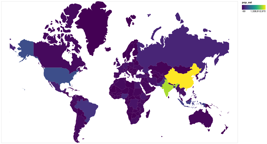
Example

import altair as alt
import geopandas as gpd
import gpdvega

alt.renderers.enable('notebook') # render for Jupyter Notebook

world = gpd.read_file(gpd.datasets.get_path('naturalearth_lowres'))

# GeoDataFrame could be passed as usual pd.DataFrame
alt.Chart(world[world.continent!='Antarctica']).mark_geoshape(
).project(
).encode(
    color='pop_est', # shorthand infer types as for regular pd.DataFrame
    tooltip='id:Q' # GeoDataFrame.index is accessible as id
).properties(
    width=500,
    height=300
)

output

Install

Dependencies

gpdvega requires:

  • Altair (>= 2.2.0 )
  • GeoPandas (>= 0.4.0)

User installation

using pip

pip install gpdvega

Changelog

See the changelog for a history of notable changes to gpdvega

Implemented a Google Maps prototype that provides the shortest route in terms of distance

Implemented a Google Maps prototype that provides the shortest route in terms of distance, the fastest route, the route with the fewest turns, and a scenic route that avoids roads when provided a sou

1 Dec 26, 2021
A part of HyRiver software stack for handling geospatial data manipulations

Package Description Status PyNHD Navigate and subset NHDPlus (MR and HR) using web services Py3DEP Access topographic data through National Map's 3DEP

Taher Chegini 5 Dec 14, 2022
Get Landsat surface reflectance time-series from google earth engine

geextract Google Earth Engine data extraction tool. Quickly obtain Landsat multispectral time-series for exploratory analysis and algorithm testing On

Loïc Dutrieux 50 Dec 15, 2022
Use Mapbox GL JS to visualize data in a Python Jupyter notebook

Location Data Visualization library for Jupyter Notebooks Library documentation at https://mapbox-mapboxgl-jupyter.readthedocs-hosted.com/en/latest/.

Mapbox 620 Dec 15, 2022
ESMAC diags - Earth System Model Aerosol-Cloud Diagnostics Package

Earth System Model Aerosol-Cloud Diagnostics Package This Earth System Model (ES

Pacific Northwest National Laboratory 1 Jan 04, 2022
Pure Python NetCDF file reader and writer

Pyncf Pure Python NetCDF file reading and writing. Introduction Inspired by the pyshp library, which provides simple pythonic and dependency free data

Karim Bahgat 14 Sep 30, 2022
Satellite imagery for dummies.

felicette Satellite imagery for dummies. What can you do with this tool? TL;DR: Generate JPEG earth imagery from coordinates/location name with public

Shivashis Padhi 1.8k Jan 03, 2023
Starlite-tile38 - Showcase using Tile38 via pyle38 in a Starlite application

Starlite-Tile38 Showcase using Tile38 via pyle38 in a Starlite application. Repo

Ben 8 Aug 07, 2022
Logging the position of the car on an sdcard

audi-mmi-3g-gps-logging Logging the position of the car on an sdcard, startup script origin not clear to me, logging setup and time change is what I d

2 May 31, 2022
GeoIP Legacy Python API

MaxMind GeoIP Legacy Python Extension API Requirements Python 2.5+ or 3.3+ GeoIP Legacy C Library 1.4.7 or greater Installation With pip: $ pip instal

MaxMind 230 Nov 10, 2022
A Python package for delineating nested surface depressions from digital elevation data.

Welcome to the lidar package lidar is Python package for delineating the nested hierarchy of surface depressions in digital elevation models (DEMs). I

Qiusheng Wu 166 Jan 03, 2023
Earthengine-py-notebooks - A collection of 360+ Jupyter Python notebook examples for using Google Earth Engine with interactive mapping

earthengine-py-notebooks A collection of 360+ Jupyter Python notebook examples for using Google Earth Engine with interactive mapping Contact: Qiushen

Qiusheng Wu 1.1k Dec 29, 2022
PySAL: Python Spatial Analysis Library Meta-Package

Python Spatial Analysis Library PySAL, the Python spatial analysis library, is an open source cross-platform library for geospatial data science with

Python Spatial Analysis Library 1.1k Dec 18, 2022
An API built to format given addresses using Python and Flask.

An API built to format given addresses using Python and Flask. About The API returns properly formatted data, i.e. removing duplicate fields, distingu

1 Feb 27, 2022
A Python interface between Earth Engine and xarray

eexarray A Python interface between Earth Engine and xarray Description eexarray was built to make processing gridded, mesoscale time series data quic

Aaron Zuspan 159 Dec 23, 2022
framework for large-scale SAR satellite data processing

pyroSAR A Python Framework for Large-Scale SAR Satellite Data Processing The pyroSAR package aims at providing a complete solution for the scalable or

John Truckenbrodt 389 Dec 21, 2022
geobeam - adds GIS capabilities to your Apache Beam and Dataflow pipelines.

geobeam adds GIS capabilities to your Apache Beam pipelines. What does geobeam do? geobeam enables you to ingest and analyze massive amounts of geospa

Google Cloud Platform 61 Nov 08, 2022
Daily social mapping project in November 2021. Maps made using PyGMT whenever possible.

Daily social mapping project in November 2021. Maps made using PyGMT whenever possible.

Wei Ji 20 Nov 24, 2022
Geospatial web application developed uisng earthengine, geemap, and streamlit.

geospatial-streamlit Geospatial web applications developed uisng earthengine, geemap, and streamlit. App 1 - Land Surface Temperature A simple, code-f

13 Nov 27, 2022
A Python tool to display geolocation information in the traceroute.

IP2Trace Python IP2Trace Python is a Python tool allowing user to get IP address information such as country, region, city, latitude, longitude, zip c

IP2Location 22 Jan 08, 2023