LEOGPS - Satellite Navigation with GPS on Python!

Overview

https://raw.githubusercontent.com/sammmlow/LEOGPS/master/docs/_static/leogps_logo.png

Project: LEOGPS
Github: https://github.com/sammmlow/LEOGPS
Documents: https://leogps.readthedocs.io/en/latest/
Version: 1.3 (Latest)

docs license

Author: Samuel Y. W. Low

linkedin orcid

LEOGPS

LEOGPS is an open-source Python software which performs relative satellite navigation between two formation flying satellites, with the objective of high accuracy relative positioning. Specifically, LEOGPS solves for the double-differenced baseline (using float ambiguity resolution) between satellites flying in formation in Low Earth Orbit (LEO). As such, the relative positioning accuracy diminishes with increasing formation baseline lengths.

LEOGPS currently supports only observations from the GPS constellation (L1/L2 frequency), with observation files in RINEX v2.XX format. LEOGPS also uses the precise ephemeris (.EPH) and clock bias and drift files (.CLK) provided by the University of Bern, Center for Orbit Determination in Europe (โ€‹CODE). As such, the coordinate frame used in the relative positioning is the International Terrestrial Reference Frame (ITRS) which is an Earth-Centered Earth-Fixed (ECEF) frame. Since the ephemeris files and RINEX v2 observations default to GPS Time, it is very important to also note that the time scale used in LEOGPS output files is GPS Time (as opposed to UTC).

This project also gives sincere appreciation and credit to the University of Bern, for their provision of the CODE FTP.

Installation and First Steps

First, clone this repository by running in your terminal (or Git Bash):

git clone https://github.com/sammmlow/LEOGPS.git

Second, you should do a pip install in your terminal of Martin Valgur's Pythonic translation of Yuri Hatanaka's compression library for RINEX files

pip install hatanaka

The Hatanaka library in Python was kindly contributed by Martin Valgur in v1.1, and replaces the older "RNX2CRX" (and GZIP, thanks to the unlzw3 library) which are Windows-only executables, making the (de)compression possible across all platforms.

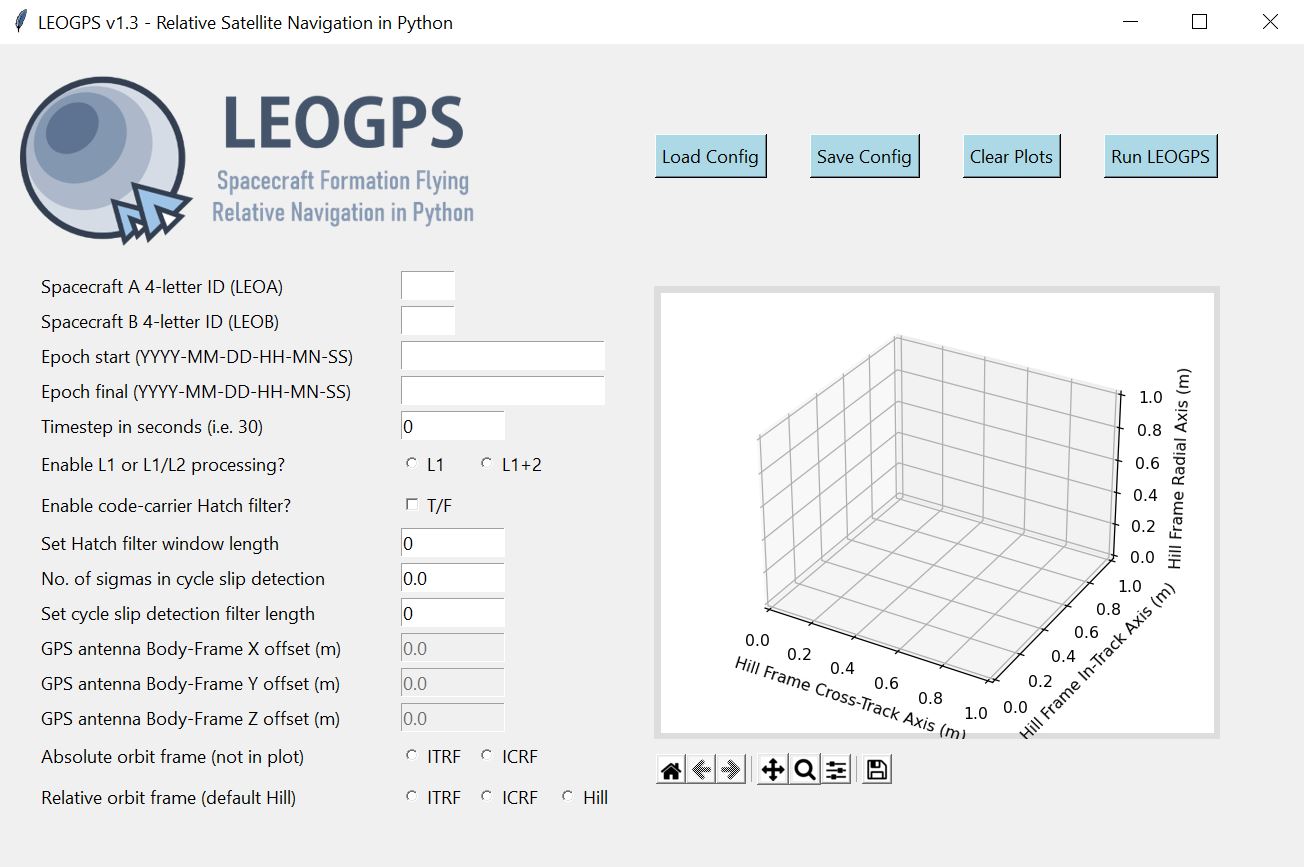
The user can then run the application by running 'leogps.py', in the main directory, and you should see the LEOGPS GUI launch:

https://raw.githubusercontent.com/sammmlow/LEOGPS/master/docs/_static/gui-v1-3.jpg

Next, you can paste the two RINEX observation files of your LEO satellite pairs in the inputs folder, key in your configuration parameters, and hit the 'Run LEOGPS' button. That's it! LEOGPS will automatically source for the precise daily ephemeris and clock solutions, and process the raw GPS measurements to produce a report file in "LEOGPS_Results.txt" comprising:

  • The single point positions and velocities of both LEOs.
  • Precise baseline vectors between the two LEOs.
  • Dilution of precision values.

LEOGPS will also output plots and reports on the interpolated GPS satellite ephemeris and clock biases.

For full documentation, please refer to the LEOGPS Read-The-Docs.

Other Package Dependencies

Recommended Python Version > 3.6

Core libraries necessary: NumPy (v1.14 and above), matplotlib, hatanaka

Standard Python libaries: os, copy, math, datetime, decimal, shutil, subprocess, warnings, urllib.request

Libraries for GUI: PIL, tkinter

Tested on Python version 3.6.5 (Anaconda with default packages).

Contact

If you have any queries feel free to reach out to me at:

[email protected]

linkedin orcid

Last Modified on 20-Sep-2021

Comments
  • Large Oscillatory Position Errors After Receiver Clock Sync

    Large Oscillatory Position Errors After Receiver Clock Sync

    Current solutions tested on GRACE A/B formation flying satellites, exhibit positioning errors from pseudo-range solutions on the order of ~100m, and relative navigation inaccuracies in double digit centimeters. This is two orders of magnitude worse off than expected from typical precise orbit determination results used as a comparison. Ephemeris errors accruing from the orbit interpolation of the GPS satellites seem to be responsible. Current orbit interpolation uses an 11th Order Lagrange Polynomial Interpolation. A review of current range measurement modelling, and the setup of the non-linear least squares, should be conducted.

    bug 
    opened by sammmlow 3
  • Add for cross-compatibility on Linux (tested on Ubuntu 18.04).

    Add for cross-compatibility on Linux (tested on Ubuntu 18.04).

    Previous usage of '\' character conflicts with UNIX file format. Used os.sep to delineate file path for both Linux and windows ( likely MacOS as well) .

    opened by ANDREWNGT 1
  • Functionality to adjust GUI

    Functionality to adjust GUI

    Is there a way to adjust the GUI or to enable scrolling? Currently the GUI is cutoff at 40% height ("Set window length for cycle slip detection filter") on my machine. Resizing the GUI also does not resolve the issue. LEOGPS GUI

    opened by ANDREWNGT 1
  • ๐ŸŒ โค๏ธ  LEOGPS v1.2 Pre-release Goals (Spoiler Alert)

    ๐ŸŒ โค๏ธ LEOGPS v1.2 Pre-release Goals (Spoiler Alert)

    Goal ๐ŸŽฏ : Build a feature that enables relative orbit plotting.

    Feature ๐Ÿ‘๏ธ : Allow the plot to be displayed directly on the LEOGPS GUI, in Hill Frame coordinates after RSN.

    Requires ๐Ÿง  : More formation flying RINEX v2 files for validation of RSN and plotting accuracy.

    documentation enhancement help wanted 
    opened by sammmlow 1
  • Use external Hatanaka library for RINEX decompression

    Use external Hatanaka library for RINEX decompression

    Hi! I recently created a carefully packaged and wrapped version of the RNXCMP tools in Python as the Hatanaka library. It simplifies the installation and usage of the tools and also makes sure any errors are raised as proper exceptions and warnings as Python warnings. In addition to the Hatanaka decompression it can also take care of the .gz/.Z compression usually applied on top of Hatanaka compression.

    I thought you might find the library useful as well. It should make sharing using of this library quite a bit simpler, I hope, as it gets rid of the need to bundle the crx2rnx and gzip executable. One caveat, though, is that it sets the minimum Python version to 3.6+, but I doubt it's an issue since Python 2 has been EOL-ed for a while now.

    opened by valgur 1
  • Use ncompress for LZW decompression

    Use ncompress for LZW decompression

    Hello again, This PR is a small follow-up to #2, which replaces the unlzw3 LZW (.Z file) decompression with the new ncompress library. It's about 40x faster than unlzw3, which is quite noticeable when some of the 10 MB RINEX files take multiple seconds to decompress with unlzw3, and it's already installed transitively with hatanaka anyway.

    opened by valgur 0
  • Added functionality to save to a relative file path.

    Added functionality to save to a relative file path.

    Issue: Saving to 1 input and 1 output clutters the folder environment

    Proposed solution: With 1 campaign name, save input and outputs like so input output | | | | campaign name campaign name

    Note: I'm not sure if this is most efficient. Maybe making the "campaign name" the parent folder instead of child folder would be easier. Following the Bernese campaign file hierarchy? In that case changes are only repositioning the directory names in gpsxtr.py, leorun.py, leogui.py, pubplt.py and rnpath.py

    opened by ANDREWNGT 0
  • To-Do: Ground Track and Orbit Visualization ๐ŸŒ ๐ŸŒŽ ๐ŸŒ

    To-Do: Ground Track and Orbit Visualization ๐ŸŒ ๐ŸŒŽ ๐ŸŒ

    ๐Ÿง  ๐Ÿง  ๐Ÿง  Future Work: With the implementation of the coordinate frame transformation, tools are now available to perform both an orbit (ICRF) visualisation as well as a ground track (ITRF) visualisation.

    • Optional add-ons: zoom-able maps will be nice.
    enhancement 
    opened by sammmlow 0
  • To-Do: Processing Statistics ๐Ÿ“Š

    To-Do: Processing Statistics ๐Ÿ“Š

    ๐Ÿง  ๐Ÿง  ๐Ÿง  Future Work: Inclusion of the processing statistics, such as pseudo range residuals, carrier to noise ratios, number of satellites in view, time series plot of which frequency signals were received.

    enhancement 
    opened by sammmlow 0
  • To-Do: Single Satellite Precise Orbit Determination ๐Ÿ›ฐ๏ธ ๐ŸŒ 

    To-Do: Single Satellite Precise Orbit Determination ๐Ÿ›ฐ๏ธ ๐ŸŒ 

    ๐Ÿง  ๐Ÿง  ๐Ÿง  Future work: to include single-satellite cases ๐Ÿ›ฐ๏ธ . The GUI should offer to the user the option of choosing single satellite processing (precise orbit determination) or dual satellite processing (relative navigation via double differencing).

    To-Do:

    • Statistical orbit determination module
    • Options for inclusion of pseudorange or carrier phase or both
    enhancement 
    opened by sammmlow 3
  • To-Fix: GPS Antenna Offsets ๐Ÿ“ก๐Ÿ“ก ๐Ÿ“ก

    To-Fix: GPS Antenna Offsets ๐Ÿ“ก๐Ÿ“ก ๐Ÿ“ก

    โš ๏ธโš ๏ธโš ๏ธ Caution: Do not apply GPS antenna offsets as of v1.3 (pre-release). โš ๏ธโš ๏ธโš ๏ธ

    GPS antenna offsets should be done in the spacecraft body frame. However, currently as LEOGPS has no feature to read in spacecraft attitude coordinates, it will not be able to tell the orientation of the spacecraft and thus applying GPS antenna offsets using XYZ coordinates in the orbit frame is erroneous. For now, this has been (conveniently) cast to future work, and users are advised not to set any non-zero offsets. The input box in the GUI has also been closed. Thus, all coordinates computed in LEOGPS of the spacecraft(s) are not of the spacecraft center of mass, but of the GPS antenna phase center.

    invalid 
    opened by sammmlow 3
Releases(1.3)
  • 1.3(Sep 22, 2021)

    ๐ŸŒ ๐Ÿ“ก ๐ŸŒ ๐Ÿ“ก LEOGPS v1.3 Release!!! โค๏ธ โค๏ธ โค๏ธ โค๏ธ

    ...

    gui-v1-3

    ...

    • Major fix in GUI re-scaling issues due to TKinter's variability in screen resolution.
    • Documented LEOGPS functions with in-depth docstrings according to PEP 257 conventions.
    • Temporarily disabled GPS Antenna Offsets (since no body-to-orbit-frame conversion feature exists yet.
    • Removed extraneous GUI parameters.
    • Cleaned up documentation and comments in the code.
    Source code(tar.gz)
    Source code(zip)
  • 1.2(Aug 9, 2021)

    ๐ŸŽฏ LEOGPS v1.2 now supports coordinate reference frame transformation (ITRF, ICRF, and Euler-Hill for formation flying visualisation). An embedded Matplotlib graph is now included in the GUI for ease of visualisation (recommended to be set to the Hill frame).

    gui-v12

    Source code(tar.gz)
    Source code(zip)
  • 1.1(Apr 15, 2021)

    Latest release for LEOGPS v1.1

    Replaced Hatanaka executable with Martin Valgur's Pythonic translation:

    • The Hatanaka library in Python was kindly contributed by Martin Valgur in v1.1, and replaces the older "RNX2CRX" (and GZIP, thanks to the unlzw3 library) which are Windows-only executables, making the (de)compression possible across all platforms.
    Source code(tar.gz)
    Source code(zip)
  • 1.0(Mar 29, 2021)

    Official stable release for LEOGPS v1.0!

    Major bug fixes:

    • Fixed ~50m positioning errors in single point positioning (posvel.py) as GPS satellite motion across signal time of flight was not accounted for previously.

    • Fixed velocity estimation accuracy in the absence of Doppler data, by improving the polynomial interpolation of carrier phase; velocity estimates of LEO satellites, even without Doppler readings, can now be estimated with errors ~1m/s.

    • Full documentation for the LEOGPS software is now provided on a read-the-docs template.

    • Included receiver clock bias estimation errors in the final output report.

    Source code(tar.gz)
    Source code(zip)
  • 0.3(Jan 12, 2021)

    LEOGPS is an open-source Python package for absolute and relative satellite navigation, with specific intent for relative navigation between formation flying satellites. It currently supports only observations from the GPS constellation, up to L1/L2 frequency, with input files as RINEX v2.XX. It uses ephemeris and clock files from the University of Bern, CODE, in v0.3.

    Source code(tar.gz)
    Source code(zip)
Owner
Samuel Low
โ™ฅ๏ธ Space ๐ŸŒŒ Orbits ๐Ÿš€ Tech ๐Ÿ“ก Earth ๐ŸŒ Nature ๐ŸŒณ Life ๐Ÿข
Samuel Low
List of Land Cover datasets in the GEE Catalog

List of Land Cover datasets in the GEE Catalog A list of all the Land Cover (or discrete) datasets in Google Earth Engine. Values, Colors and Descript

David Montero Loaiza 5 Aug 24, 2022
Python ๅฐ็ฃ่กŒๆ”ฟๅ€ๅœฐๅœ– (2021)

Python ๅฐ็ฃ่กŒๆ”ฟๅ€ๅœฐๅœ– (2021) ไปฅ python ่ฎ€ๅ–ๆ”ฟๅบœ้–‹ๆ”พๅนณๅฐ็š„ ShapeFile ๅœฐๅœ–่ณ‡่จŠใ€‚ๆญก่ฟŽๅผ•็”จๆˆ–ๆ˜ฏๅ”ไฝœ ๅฆๆœ‰็ธฃๅธ‚่ณ‡่จŠใ€ๆ‘้‡Œ่ณ‡่จŠ่ˆ‡ๅ„็จฎ่กŒๆ”ฟๅœฐๅœ–่ณ‡่จŠ ไพ‹ๅฆ‚๏ผš ็›ด่ฝ„ๅธ‚ใ€็ธฃๅธ‚็•Œ็ทš(TWD97็ถ“็ทฏๅบฆ) ้„‰้Žฎๅธ‚ๅ€็•Œ็ทš(TWD97็ถ“็ทฏๅบฆ) | ๆ”ฟๅบœ่ณ‡ๆ–™้–‹ๆ”พๅนณ่‡บ: https://data

WeselyOng 12 Sep 27, 2022
A Python interface between Earth Engine and xarray

eexarray A Python interface between Earth Engine and xarray Description eexarray was built to make processing gridded, mesoscale time series data quic

Aaron Zuspan 159 Dec 23, 2022
This is the antenna performance plotted from tinyGS reception data.

tinyGS-antenna-map This is the antenna performance plotted from tinyGS reception data. See their repository. The code produces a plot that provides Az

Martin J. Levy 14 Aug 21, 2022
When traveling in the backcountry during winter time, updating yourself on current and recent weather data is important to understand likely avalanche danger.

Weather Data When traveling in the backcountry during winter time, updating yourself on current and recent weather data is important to understand lik

Trevor Allen 0 Jan 02, 2022
An API built to format given addresses using Python and Flask.

An API built to format given addresses using Python and Flask. About The API returns properly formatted data, i.e. removing duplicate fields, distingu

1 Feb 27, 2022
pure-Python (Numpy optional) 3D coordinate conversions for geospace ecef enu eci

Python 3-D coordinate conversions Pure Python (no prerequistes beyond Python itself) 3-D geographic coordinate conversions and geodesy. API similar to

Geospace code 292 Dec 29, 2022
Daily social mapping project in November 2021. Maps made using PyGMT whenever possible.

Daily social mapping project in November 2021. Maps made using PyGMT whenever possible.

Wei Ji 20 Nov 24, 2022
This app displays interesting statistical weather records and trends which can be used in climate related research including study of global warming.

This app displays interesting statistical weather records and trends which can be used in climate related research including study of global warming.

0 Dec 27, 2021
Solving the Traveling Salesman Problem using Self-Organizing Maps

Solving the Traveling Salesman Problem using Self-Organizing Maps This repository contains an implementation of a Self Organizing Map that can be used

Diego Vicente 3.1k Dec 31, 2022
Python interface to PROJ (cartographic projections and coordinate transformations library)

pyproj Python interface to PROJ (cartographic projections and coordinate transformations library). Documentation Stable: http://pyproj4.github.io/pypr

832 Dec 31, 2022
A NASA MEaSUREs project to provide automated, low latency, global glacier flow and elevation change datasets

Notebooks A NASA MEaSUREs project to provide automated, low latency, global glacier flow and elevation change datasets This repository provides tools

NASA Jet Propulsion Laboratory 27 Oct 25, 2022
A Django application that provides country choices for use with forms, flag icons static files, and a country field for models.

Django Countries A Django application that provides country choices for use with forms, flag icons static files, and a country field for models. Insta

Chris Beaven 1.2k Jan 03, 2023
Interactive Maps with Geopandas

Create Interactive maps ๐Ÿ—บ๏ธ with your geodataframe Geopatra extends geopandas for interactive mapping and attempts to wrap the goodness of amazing map

sangarshanan 46 Aug 16, 2022
Open Data Cube analyses continental scale Earth Observation data through time

Open Data Cube Core Overview The Open Data Cube Core provides an integrated gridded data analysis environment for decades of analysis ready earth obse

Open Data Cube 410 Dec 13, 2022
Python script to locate mobile number

Python script to locate mobile number How to use this script run the command to install the required libraries pip install -r requirements.txt run the

Shekhar Gupta 8 Oct 10, 2022
A part of HyRiver software stack for handling geospatial data manipulations

Package Description Status PyNHD Navigate and subset NHDPlus (MR and HR) using web services Py3DEP Access topographic data through National Map's 3DEP

Taher Chegini 5 Dec 14, 2022
Zora is a python program that searches for GeoLocation info for given CIDR networks , with options to search with API or without API

Zora Zora is a python program that searches for GeoLocation info for given CIDR networks , with options to search with API or without API Installing a

z3r0day 1 Oct 26, 2021
Use Mapbox GL JS to visualize data in a Python Jupyter notebook

Location Data Visualization library for Jupyter Notebooks Library documentation at https://mapbox-mapboxgl-jupyter.readthedocs-hosted.com/en/latest/.

Mapbox 620 Dec 15, 2022
3D extension built off of shapely to make working with geospatial/trajectory data easier in python.

PyGeoShape 3D extension to shapely and pyproj to make working with geospatial/trajectory data easier in python. Getting Started Installation pip The e

Marc Brittain 5 Dec 27, 2022